From DA Photomontages to Final Compliance – Central Coast Surveyors Supporting Projects from Concept to Completion

A successful development project requires accurate surveying at every stage, from the initial design and Development Application (DA) through to construction and final compliance.

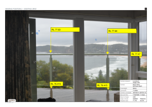
Central Coast Surveyors worked closely with the project’s consultants, providing essential surveying information to assist in preparing photomontages for inclusion in the Development Application package.

By providing accurate site survey information, including existing ground levels, site features and spatial data, we helped establish a reliable surveying foundation for the consultants to produce photomontages illustrating the proposed development in its surrounding environment.

Supporting the Development Application Process

Photomontages are an important visual component of many Development Applications, helping Councils, planning consultants and other stakeholders understand how a proposed development will integrate with its existing surroundings.

Accurate survey information is fundamental to producing meaningful visual representations. Our involvement helped the project consultants work from reliable site information when preparing the visual material required for the DA submission.

Our assistance continued beyond the initial survey, with Central Coast Surveyors remaining involved throughout the DA phase, providing further surveying support as the project progressed.

From DA Approval to Construction Set-Out

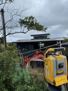
Once the project moved towards construction, Central Coast Surveyors continued working with the project team, undertaking the construction set-out to transfer the approved design onto the ground.

This stage is critical to ensuring the proposed works are positioned correctly in accordance with the approved plans and design documentation.

Maintaining continuity with the surveying team involved during the earlier planning stages provides valuable familiarity with the site, project documentation and design requirements.

Final Compliance Survey

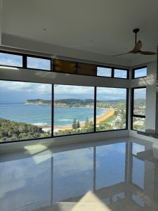
Following completion of the construction works, Central Coast Surveyors returned to undertake the final compliance survey.

This survey provided the necessary verification of the completed works against the relevant approved design and documentation, supporting the project’s final compliance requirements.

One Surveying Team Throughout the Project

This project demonstrates the value of having a local, registered surveying consultancy involved throughout the entire development process.

From providing accurate survey information for consultant-prepared DA photomontages, assisting during the Development Application phase, undertaking construction set-out and completing the final compliance survey, Central Coast Surveyors delivered continuous surveying support from planning through to completion.

Central Coast Surveyors – Professional surveying, modern technology and dependable support at every stage of your development.

Can Strata Lots Share a Driveway in NSW?

Can Strata Lots Share a Driveway in NSW?

A driveway can look like a simple strip of concrete, but its legal status can affect every owner’s ability to park, build, sell or renovate. So, can strata lots share driveways? Yes, they can, and it is common in NSW strata developments. The key question is not whether two or more lots physically use the driveway. It is who owns it, who has rights to use it, and how those rights are recorded.

For a small dual occupancy conversion, townhouse project or larger strata scheme on the Central Coast, that answer should be resolved before plans are lodged or construction starts. A registered surveyor can establish the physical and title position, while the strata plan, by-laws and, where needed, legal advice determine the rights and responsibilities that follow.

Can strata lots share driveways under a strata plan?

In most conventional strata schemes, a shared driveway is created as common property. It sits outside the boundaries of individual lots and is available for use by lot owners and occupiers in accordance with the scheme’s by-laws. The owners corporation is generally responsible for maintaining and repairing common property, funded through levies paid by lot owners.

This structure makes practical sense where the driveway provides the only vehicle access to garages, parking spaces, visitor bays or bin areas. Rather than giving one owner control over a route everyone needs, the driveway remains part of the common property shared by the scheme.

That does not mean every owner may use it however they choose. Parking on the driveway, storing boats or trailers, installing a gate, placing rubbish bins or obstructing access can all be controlled by by-laws. A driveway that is common property is shared access, not an extension of any one lot’s private yard.

The boundary shown on the registered strata plan matters

The answer is found by reading the registered strata plan, not by relying on fences, garden edges, paving changes or an agent’s description. A strata plan defines the lot boundaries and identifies common property. In many schemes, lot boundaries are defined by building structure, often the inner surface of walls, floors and ceilings. Open areas, accessways and driveways may therefore be common property even when they sit directly beside one particular dwelling.

There are exceptions. A driveway or parking area can form part of an individual lot if the strata plan includes it within that lot’s boundary. In that case, another lot does not automatically have a right to drive over it merely because it has done so historically. Access rights need to be clearly created and documented.

This is particularly relevant in older developments, informal subdivisions and sites that have been altered over time. A gate may have moved, a carport may have been added, or parking arrangements may have developed by agreement between neighbours. None of these changes necessarily alter title boundaries or legal access rights.

An identification survey or cadastral assessment can help confirm how existing improvements relate to the title and strata plan. That information is valuable before buying, undertaking building work, applying for a building certificate, or trying to resolve a disagreement about access.

When an easement may be needed

An easement for access is more commonly associated with separate Torrens title lots than lots in the same strata scheme. For example, two adjoining houses on separate titles may share a battle-axe driveway, with one owner using land owned by the other. An easement registered on title gives the benefiting land a legal right of passage and sets out the affected area.

Within a strata scheme, common property often removes the need for an access easement between lots. However, easements can still be required where access crosses land outside the scheme, serves another parcel, connects to a public road, or involves services such as drainage, water or electricity.

The right solution depends on the proposed title structure. It should be considered early, alongside the development layout, vehicle turning requirements, fire access, stormwater design and council controls. Leaving access arrangements until the end can lead to redesign, additional approvals and delays to registration.

Easements and by-laws do different jobs

An easement is a property right registered on title. It usually benefits land rather than a particular person and remains relevant when the property is sold.

A by-law regulates conduct and use within a strata scheme. It may deal with matters such as parking, gates, exclusive use areas, maintenance obligations and restrictions on obstructing common property. A by-law cannot safely be treated as a substitute for an easement where a registered property right is required.

For instance, an exclusive use by-law may permit a lot owner to use a defined part of common property, perhaps an adjacent courtyard or parking space. It should clearly address who maintains that area, whether it can be altered and whether other owners retain access rights. The wording and plan attached to the by-law need to align with the registered strata plan.

Who pays for a shared strata driveway?

Where the driveway is common property, the owners corporation will generally arrange and fund maintenance and repairs through the strata scheme. Costs are usually shared through levies based on unit entitlements, rather than according to which owners use the driveway most often.

That can feel uneven in a scheme where one lot has direct street access and rarely drives over the shared area. However, common property expenses are ordinarily collective expenses unless a valid arrangement provides otherwise. Owners should check the scheme’s by-laws, any special resolutions and the strata managing agent’s records before assuming a cost can be passed to one neighbour.

If an owner has exclusive use of a common property driveway or parking area, the by-law may make that owner responsible for specific maintenance. Clear drafting is essential. It should address routine upkeep, damage from vehicles, resurfacing, drainage, gates, lighting and insurance implications. Vague agreements tend to become difficult when the surface fails or ownership changes.

Common issues that cause driveway disputes

Shared driveways work well when the title structure and day-to-day rules match. Problems usually arise when physical use gets ahead of documentation. A resident may park in a turning area, install a bollard, narrow access with landscaping or claim an area as private because it is beside their lot.

Construction is another frequent trigger. Extensions, new garages, retaining walls and fencing can encroach onto common property or reduce the width needed for vehicle access. Before design is finalised, an accurate detail and contour survey can show levels, structures, visible boundaries and access constraints. A registered surveyor can then set out approved works so they are positioned correctly on site.

For proposed strata subdivisions, the driveway should also be assessed in practical terms. Can vehicles enter and leave safely? Is there adequate clearance for garages? Where will services run? Does the layout allow for drainage and future maintenance? A plan that works on paper but creates a tight or poorly drained accessway can create long-term costs for every owner.

A practical process before building, buying or subdividing

Start with the registered title documents and strata plan. These establish the legal framework, but they may not explain every visible feature on the ground. Compare them with a current survey where there is uncertainty about boundaries, common property, structures or access.

For a proposed project, involve the surveyor early with the architect, planner and engineer. The survey information can support design decisions before expensive drawings are completed. If an easement, strata by-law or owners corporation approval may be needed, identify it before works commence rather than after a contractor is booked.

It is also wise to obtain legal advice from a property or strata lawyer where access rights are unclear or disputed. Surveyors determine boundaries and prepare plans for registration; lawyers advise on the legal effect of titles, easements, agreements and by-laws. Those roles work best together.

Central Coast Surveyors assists property owners and project teams with the surveys and subdivision plans needed to clarify site conditions and support compliant title outcomes. Early, accurate survey work gives the rest of the consultant team a reliable basis for decisions.

A shared driveway should make a development easier to use, not become the issue that holds up a sale, approval or build. Establish the ownership, access rights and maintenance responsibilities while there is still room to make the right arrangement.

Survey Guide for Waterfront Properties

Survey Guide for Waterfront Properties

A waterfront block can look straightforward from the street and become far more complicated at the water’s edge. This survey guide for waterfront properties explains the checks that matter before a purchase, waterfront licence transfer, renovation, new jetty, seawall work or subdivision in NSW.

The key issue is simple: the edge of occupation is not always the legal property boundary. Fences, lawns, steps, pontoons, retaining walls and boat sheds may sit near, on or beyond the title boundary. A registered surveyor can establish the relationship between those improvements, the title and the relevant waterfront tenure so decisions are based on evidence rather than assumptions.

Why waterfront land needs closer survey attention

Waterfront properties can involve private title land, Crown land, a waterway, tidal land and licensed occupation within the same small area. On the Central Coast, this is particularly relevant around estuaries, bays, lakes and riverfront locations where long-standing structures may not align neatly with modern title information.

A deposited plan and title search are essential starting points, but they do not show every physical feature on site or confirm where a fence has been built. They also do not replace a survey where the boundary position, encroachment risk or extent of waterfront improvements matters.

Changes to the shoreline can add another layer. Natural processes, past filling, erosion, seawall construction and vegetation can make the apparent edge of land unreliable as a boundary reference. Where land adjoins tidal waters, the legal boundary description and survey evidence need careful interpretation. This is work for a registered surveyor, not a visual estimate taken from an aerial image or old fencing.

The survey guide for waterfront properties: start with the right purpose

The right survey depends on the decision being made. Ordering a broad survey without a defined purpose can create delay and unnecessary cost, while relying on the wrong report can leave a critical question unanswered.

Buying, selling or transferring a waterfront licence

If you are purchasing a waterfront property, an identification survey may be appropriate where there are concerns about boundary occupation, structures close to boundaries or improvements near the water. It identifies visible improvements in relation to the title boundaries and can reveal issues requiring further investigation before settlement.

For a waterfront licence transfer, accurate information about the licensed area and the structures within it is often required. A survey may be needed to show items such as a jetty, pontoon, ramp, slipway, retaining wall, stairs or boat shed in relation to the property and waterfront area. The exact requirements depend on the licence, the relevant authority and the nature of the occupation.

Do not assume a licence automatically transfers with the sale of the land, or that every existing structure is covered by it. Your conveyancer or solicitor can advise on the legal transaction, while a registered surveyor provides the spatial evidence needed to support the process.

Designing an extension or rebuilding near the foreshore

Architects, building designers and engineers need reliable levels, features and boundaries before they can design with confidence. A detail and contour survey maps the site conditions, including buildings, retaining walls, services where visible, trees, slopes, access points and waterfront structures. It provides a base plan for design and can help identify practical constraints early.

On a sloping waterfront site, floor levels and contours are not simply design details. They can affect drainage, access, excavation quantities, structural design and how a proposal responds to flood or coastal planning controls. Council requirements vary by location and project, so the survey should be commissioned early enough for the wider consultant team to use it properly.

If proposed works are close to a boundary, a cadastral boundary mark-out can give the builder and designer clear on-ground reference points. This is especially valuable where a structure must maintain a setback, match an approved plan or avoid an existing easement.

Replacing a jetty, seawall or waterfront access structure

Waterfront structures are rarely just construction projects. They can involve land tenure, environmental approvals, engineering design and authority requirements alongside the normal building process. A survey establishes existing conditions and provides a precise basis for plans, approvals and set-out.

The scope may need to capture the structure’s dimensions, its position relative to title boundaries, the water’s edge, adjoining occupation and levels across the foreshore. For tidal locations, the required datum and reference levels should be agreed with the project team from the outset. This avoids redesign caused by survey information that does not meet the engineer’s or approval authority’s needs.

A survey confirms location. It does not grant approval for a new or altered structure, resolve tenure rights by itself, or replace engineering advice. Clear coordination between the surveyor, designer, engineer, planner and relevant authority is what keeps the project moving.

Information to gather before engaging a surveyor

A short conversation at the beginning can save substantial time later. Provide the property address, lot and deposited plan details if available, recent title documents, any waterfront licence information and the purpose of the survey. If you have old plans, development consent, engineering drawings or correspondence about a boundary issue, include those as well.

It also helps to explain what has changed on site. Perhaps a neighbour has raised a concern about a fence, a pontoon has been replaced, a retaining wall has moved closer to the boundary, or a buyer has requested evidence before settlement. Those details help the registered surveyor recommend the correct scope rather than treating every waterfront site the same way.

Access matters too. Survey work may require entry to difficult parts of the site, including steep banks, jetties or side boundaries obscured by vegetation. Let the survey team know about locked gates, dogs, tenants, unsafe structures and access restrictions before the field visit.

Common assumptions that cause waterfront delays

The most expensive problems often start with a reasonable-sounding assumption. “The fence has always been there” does not prove it is on the boundary. “The previous owner built the jetty” does not confirm the current licence position. “The map shows the line near the water” does not establish its position on the ground to survey accuracy.

Another common issue is treating a survey as a last-minute administrative task. By the time a builder is ready to start, an unresolved boundary or waterfront tenure issue can affect construction timing, finance, design and neighbour discussions. Early survey input gives the project team time to adjust plans before commitments are locked in.

Existing marks should also be treated carefully. A peg, nail, old concrete mark or paint mark may be useful evidence, but it is not automatically a confirmed boundary mark. A registered surveyor assesses the available records and physical evidence, then applies the relevant cadastral survey principles to determine and mark boundaries where appropriate.

What a registered surveyor brings to the process

Waterfront work needs more than measurements. It requires an understanding of cadastral boundaries, survey records, plans, height datums and how the resulting information will be used by conveyancers, architects, engineers, council and waterfront authorities.

A registered surveyor is qualified to carry out cadastral surveying and determine boundary positions in accordance with the NSW framework. That distinction matters when decisions concern title boundaries, encroachments, subdivisions, easements or structures near a waterfront interface.

Modern equipment, including Trimble surveying technology, improves field efficiency and data capture. However, technology does not replace professional judgement. The value lies in combining accurate observations with title research, local site knowledge and clear plans that other project consultants can rely on.

Plan for a clear handover between consultants

The strongest waterfront projects have one agreed survey base from the beginning. The architect should receive the detail and contour survey needed for design. The engineer should receive the levels, features and datum information required for structural or civil work. The builder should receive set-out information before construction begins. If a new plan or title outcome is required, the cadastral work should be planned alongside the approval pathway rather than added at the end.

Central Coast Surveyors works with property owners and project teams to define that scope early, coordinate survey information across the project and reduce avoidable rework. For waterfront sites, that practical coordination can be just as valuable as the plan itself.

Before committing to a waterfront purchase or works near the foreshore, ask a registered surveyor what the existing evidence shows, what still needs to be measured and which decisions should wait for a confirmed survey result.

What Survey Does an Architect Need for Design?

What Survey Does an Architect Need for Design?

An architect can produce a far better concept when the site information is right from the start. So, what survey does an architect need? For most new homes, additions and redevelopment projects, the answer is a current detail and contour survey, often supported by boundary information or an identification survey where title and built improvements need checking.

The right survey is not an administrative extra. It is the base information that lets an architect position a building confidently, respond to slope, manage drainage, protect trees, understand neighbouring conditions and prepare plans that are less likely to require redesign later. On the Central Coast, where steep blocks, waterfront land, bushfire constraints and older subdivisions are common, assumptions made from aerial imagery or old plans can become expensive quickly.

What survey does an architect need before design starts?

A detail and contour survey, also called a topographic survey, is generally the first survey an architect needs. It records the physical features of a property and presents them on a scaled plan that can be used for architectural design, consultant coordination and development applications.

A registered surveyor attends the site and measures the features that affect design decisions. This commonly includes site levels and contours, existing buildings, fences, driveways, retaining walls, visible services, kerbs, footpaths, trees, poles, drainage pits and significant changes in ground level. The survey can also show adjoining building locations and visible features near the boundaries where they may affect privacy, overshadowing, access or construction.

For an architect, this information answers practical questions early. Can the proposed floor level work with the slope? Is a cut-and-fill solution likely to be reasonable? Where can stormwater be directed? Does the existing driveway grade suit a garage? How high will a new dwelling sit relative to its neighbours?

Without accurate levels, a design may look convincing on paper but prove difficult to build, costly to excavate or unsuitable for drainage once engineering begins.

Why contours matter more than many owners expect

Contour information is particularly valuable on sloping sites in Terrigal, Avoca Beach, Copacabana, Wamberal and many hinterland areas. A modest difference in level can change the preferred building location, slab design, retaining requirements and likely construction cost.

Architects use surveyed levels to model the building against the land rather than designing around an estimate. That can reduce the risk of a later redesign after an engineer, builder or certifier identifies a problem. It also helps the design team consider accessible entries, vehicle gradients and how the home will connect to outdoor areas.

The required contour interval depends on the site and proposed work. A relatively flat suburban block may need less detailed level information than a steep waterfront site or a project involving substantial excavation. The survey brief should match the project stage and the architect’s requirements.

When boundary information is also needed

A detail and contour survey can show apparent fence lines and occupation features, but a fence is not proof of the legal boundary. This distinction matters whenever the design is close to a side, rear or waterfront boundary, or when an existing structure may encroach.

If an architect needs confirmed legal boundaries for setback design, boundary walls, a new fence, an extension near the lot line or a dispute about where the property ends, a cadastral boundary survey or boundary mark-out may be required. A registered land surveyor investigates the title evidence and relevant survey records, locates or reinstates boundary marks where possible, and determines the boundary position under NSW surveying requirements.

The practical approach varies. On some straightforward sites, an existing survey and visible marks may provide sufficient confidence for early concept work. On others, especially older properties with missing pegs, irregular boundaries or conflicting fence lines, boundary work should happen before the design is fixed.

Leaving it until construction can create avoidable pressure. If a wall, deck or garage has been designed to a presumed boundary that is later found to be elsewhere, the project may need amended plans, a new approval pathway or a more complicated construction solution.

Identification surveys for existing properties

An identification survey is often needed where the project involves an existing building and the legal relationship between improvements and boundaries must be reported. These surveys are commonly requested for council building certificates, property transactions, waterfront licence transfers or situations where an owner needs to know whether visible structures are contained within the title.

For architects, an identification survey can be helpful before major renovation work, particularly where an existing garage, deck, retaining wall or dwelling sits near a boundary. It can identify issues that influence the scope of work before time is spent developing detailed plans.

It is different from a standard topographic survey. A topographic survey describes the site for design. An identification survey focuses on identifying the land parcel and reporting the position of improvements in relation to the boundaries. Some projects require both, while others need only one. A registered surveyor can advise after reviewing the proposed works, available title documents and site conditions.

Surveys that may be required as the design develops

The initial design survey is rarely the only survey input on a project. The architect’s needs change as the proposal moves through approval and construction.

Floor level reports

A floor level report may be needed where flood planning controls, overland flow, drainage design or compliance with a specified minimum floor level is relevant. It records existing floor levels against an appropriate datum, giving architects and engineers reliable information for setting finished floor levels.

This is especially useful on low-lying land, near waterways or where council controls require a building to sit above a nominated flood planning level. It should be arranged early enough that the architecture can respond to the result, rather than treating the required level as a late constraint.

Construction set-out

Once plans are approved and construction is ready to begin, a builder may need a surveyor to set out the building position, grid lines, offsets and design levels. This converts the approved design from drawings into physical marks on site.

For architects and project managers, construction set-out provides an additional check that the building is being located as intended. It is particularly valuable for tight sites, complex geometry, boundary-adjacent work and projects with strict height or level controls.

As-built or final surveys

At completion, a final survey may be needed to show the completed work, confirm finished levels, support certification or assist with subdivision and title registration. The exact requirement depends on the consent conditions, certifier, lender and nature of the project.

Where a project includes a subdivision, strata plan, community title arrangement or easement, surveying becomes a longer process involving plan preparation, authority requirements and registration with NSW Land Registry Services. Early coordination between the architect, planner, engineer and registered surveyor helps prevent the subdivision design from clashing with the physical or legal constraints of the site.

How to brief a surveyor for architectural work

A clear brief avoids collecting information twice. Before booking a survey, provide the property address, a brief description of the proposed works, any available plans, and the architect’s preferred deliverables if they are known.

It also helps to flag specific design issues. These might include a proposed extension near a boundary, a suspected drainage problem, a need to retain mature trees, waterfront works, a new driveway, a pool, or possible subdivision. The surveyor can then recommend whether the project needs a detail and contour survey alone or a combination of topographic, identification, boundary or level information.

Architects commonly need the survey in a format suitable for CAD drafting, alongside a clear PDF plan. Asking about the required file format and coordinate or datum requirements before fieldwork begins keeps the handover efficient. Where engineers are already engaged, it is sensible to align the survey scope with their likely requirements too.

Choosing the right scope saves redesign

The cheapest survey is not always the most cost-effective one. A limited survey may suit a simple feasibility study, but it can create another site visit and delay when detailed design begins. Conversely, there is little value in commissioning boundary reinstatement work at the outset if the proposed building will sit well inside the apparent boundaries and no legal boundary issue exists.

The right scope depends on the design, site complexity and approval pathway. A registered surveyor should explain what is being measured, what the plan can be relied on for, and whether another survey type is likely to be needed later.

For a smooth start, engage the surveyor before the architect commits to the building footprint. Accurate site information gives the whole consultant team a dependable common reference point – and gives the design the best chance of working just as well on the ground as it does on screen.