How Long Does a Survey Take on the Central Coast?

How Long Does a Survey Take on the Central Coast?

A builder is ready to set out, an architect needs levels for a design, or a property sale has raised a boundary question. At that point, the practical question is: how long does a survey take? The answer depends on the type of survey, the property’s history and whether the work needs to support a council, construction or NSW Land Registry Services process.

On-site time is only one part of the job. A reliable survey also requires research, precise field measurements, calculations, and plan preparation, and it requires a registered surveyor; the survey is produced by someone trained to understand land, measurement, title, and statutory requirements, not just field capture. That distinction matters when the data will influence approvals, construction setting out and later registration work. certification. Understanding what goes into the final plan helps you allow enough time in your project programme and avoid expensive hold-ups later.

How long does a survey take from booking to plan?

For many residential jobs, the fieldwork may take from a few hours to a full day. The complete process, from instruction to receiving a usable plan, commonly takes several business days. More complex sites, title investigations, subdivisions and work requiring lodgement can take significantly longer.

A straightforward detail and contour survey of an accessible suburban block may be measured in half a day and delivered promptly once processing and drafting are complete. An identification survey, where the surveyor must investigate title boundaries and locate structures in relation to them, often needs more office-based research and checking than clients expect.

For subdivision, easement or strata work, the timeframe is usually measured in weeks or months rather than days. Surveying is one part of a larger approval and registration pathway involving planners, engineers, council, certifiers, solicitors and NSW Land Registry Services. The right survey information at the start can keep that pathway moving, but no surveyor can responsibly promise the timing of every external approval.

The survey type makes the biggest difference

Different surveys answer different questions. Choosing the right one early prevents a common problem: paying for a plan that does not provide the information your designer, builder, council or conveyancer actually needs.

Detail and contour surveys

A detail and contour survey records the existing features and levels of a site. It may show buildings, fences, driveways, retaining walls, trees, services visible on site, kerbs, drainage features and ground contours. Architects, building designers, town planners and engineers use it as the base information for design.

On a clear, accessible residential site, measurement can often be completed within a day. Processing the data into a coordinated, accurate plan then takes additional time. Sloping blocks, dense vegetation, waterfront land, larger acreage and difficult access naturally increase the field component.

Identification surveys

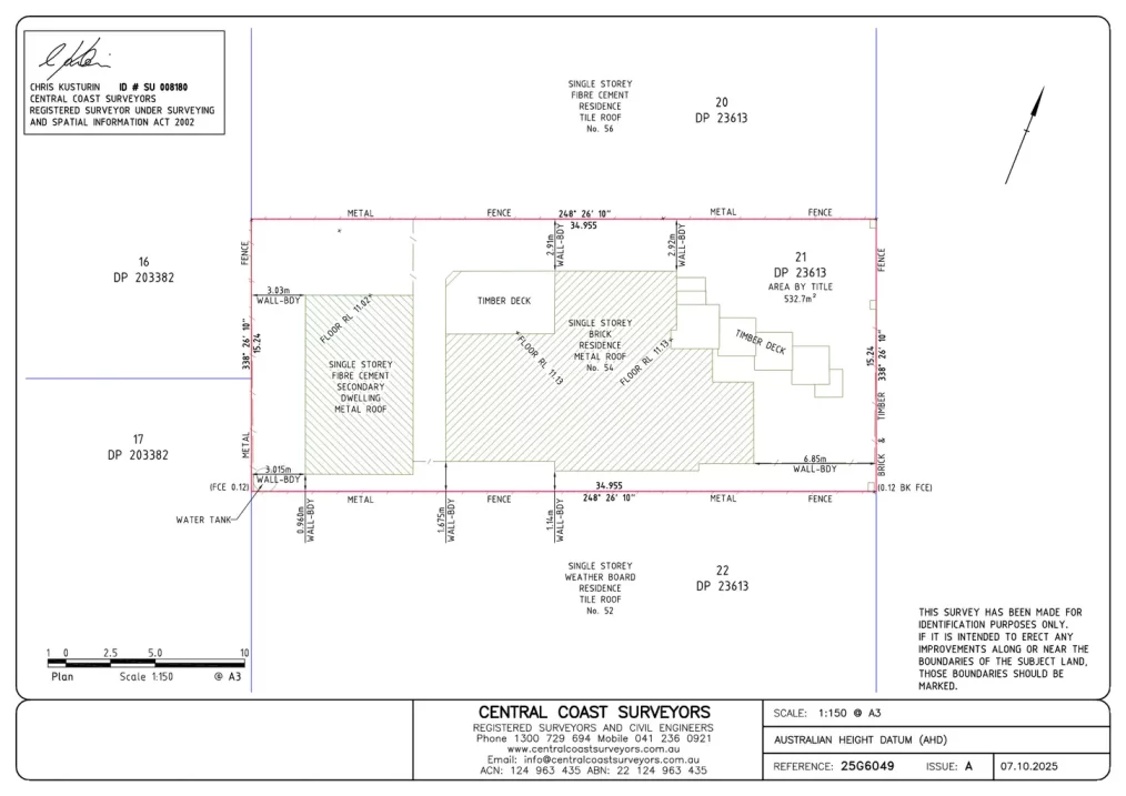
An identification survey is commonly needed for a council building certificate, a property transaction, a waterfront licence transfer or to confirm whether buildings and improvements sit within title boundaries. It is not simply a quick check of a fence line.

The surveyor reviews title information and relevant records, searches for existing marks and evidence, measures improvements, and prepares a plan that identifies any encroachments or issues requiring attention. A site visit may be relatively short, but the research and professional assessment are critical. If original marks are missing, buried or disturbed, further investigation may be needed.

Boundary mark-outs

A boundary mark-out establishes or re-establishes the position of a legal boundary on the ground. This is often requested before fencing, building close to a boundary, resolving uncertainty with a neighbour or planning a new structure.

Timing depends heavily on whether reliable survey marks can be found and verified. Older Central Coast properties, irregular lots, bush blocks and land with a long history of alterations can require more investigation than a newer estate. A registered surveyor must apply cadastral evidence correctly, rather than relying on occupation lines, old pegs or online mapping.

Construction set-out surveys

Construction set-out is usually scheduled around the builder’s programme. Once approved design information is supplied and the site is ready, a set-out can often be arranged efficiently. The work may include locating building corners, grids, excavation lines, retaining walls, roads, drainage or service works.

The key timing risk is late information. Changes to architectural or engineering drawings after set-out can mean rework on site. Providing final, coordinated plans before the survey is booked gives the construction team the best chance of staying on programme.

Floor level reports

Floor level reports generally involve measuring existing finished floor levels and relating them to an appropriate datum. They can support design decisions, flood planning, renovation work and approval documentation.

The site measurement may be completed quickly for an accessible dwelling. Delivery time will depend on the number of structures, the reporting requirements and whether additional level or boundary information is required alongside the report.

Subdivisions, strata plans and easements

Subdivisions and easement plans require careful cadastral work, plan preparation and a sequence of approvals and certifications. A Torrens title subdivision may also involve development consent, civil works, subdivision certificates, statutory certifications and plan registration. Strata and community title projects have their own documentation and coordination requirements.

The surveyor’s component should start early, often while the project is being designed. Waiting until construction is nearly complete can expose title, boundary, easement or compliance issues when there is least time to resolve them.

What can make a survey take longer?

A professional survey timeline is shaped by the evidence available, the site conditions and the intended use of the plan. Fast turnaround is valuable, but accuracy and compliance cannot be rushed.

Delays are more likely where boundaries are poorly defined, original marks cannot be readily located, access is restricted or the property has challenging terrain. Heavy vegetation, steep land, water frontage, extensive structures and large rural holdings all require more measurement and checking.

Documentation also matters. Older titles, complicated easements, prior subdivisions and inconsistencies between occupation and title boundaries may require a deeper records review. A fence is not proof of ownership, and a wall that has stood in the same place for decades is not automatically on the legal boundary.

Weather can affect some fieldwork, particularly where visibility, safety or ground access is compromised. Construction projects can also be delayed when the site is not ready, survey control has been disturbed, or other trades are working through the area that needs to be measured.

How to help your survey proceed without avoidable delays

The clearest instruction produces the best result. At the quoting stage, explain what you are planning and who needs the survey. A plan for an architect has different requirements from one needed for a building certificate, a fence dispute or title registration.

Before the site visit, provide the property address, lot and deposited plan details if available, recent plans, architectural drawings, engineering drawings, council correspondence and any information about known boundary marks. If a builder, designer or planner is involved, confirm the format and information they need from the final plan.

Access is equally important. Arrange entry to the entire property, including side yards, rear areas, under-house spaces and any locked gates. Let neighbours know if access to a shared boundary area may be needed. Move vehicles, stored materials or temporary site items where practical, and advise the surveyor of hazards such as dogs, steep banks or unprotected excavations.

For construction work, issue the latest approved drawings and confirm that design changes have been finalised. For boundary work, avoid moving suspected survey marks or starting fencing and excavation near the boundary until the survey is complete.

Why the fastest site visit is not always the fastest project outcome

It can be tempting to compare survey quotes only by the promised turnaround. However, a plan that lacks critical levels, misses relevant structures or is unsuitable for its intended approval purpose can create a much larger delay down the track.

A registered land surveyor brings the qualifications, competency and legal understanding needed for cadastral work, as well as the practical experience to identify issues before they become site problems. Modern Trimble equipment supports efficient, accurate measurement, but the equipment does not replace the professional judgement required to interpret evidence, certify plans and coordinate with the wider consultant team.

For homeowners, that may mean certainty before building a fence or purchasing a property with a questionable structure near the boundary. For architects, builders and developers, it means survey data that is fit for design, construction and compliance rather than needing to be redone mid-project.

Allow survey time before it becomes urgent

The best time to arrange a survey is usually before a design, approval, purchase or construction deadline makes it urgent. If you need a detail survey, boundary advice, identification plan, set-out or subdivision support on the Central Coast, provide the project purpose and deadline at the outset. That allows the survey scope, access requirements and delivery sequence to be planned properly – giving every other consultant a more dependable starting point.

Boundary Issues on Established Central Coast Properties

Boundary Issues on Established Central Coast Properties

A fence that has stood for 40 years, a garden bed maintained by the same family, or a neighbour’s driveway that appears to sit comfortably in place can all create a false sense of certainty. Boundary issues on established Central Coast properties often come to light only when someone plans a new build, sells, subdivides, replaces a fence or receives a concern from a neighbour. By then, the cost of getting it wrong can be far greater than the cost of confirming the boundary early.

On older residential, rural and waterfront sites, visible occupation and the legal property boundary are not always the same thing. A registered surveyor can investigate the title, relevant survey records and physical evidence on site to determine where the boundary is located and whether structures or improvements create a problem worth addressing.

Why established properties can have boundary uncertainty

Many Central Coast properties have changed hands several times and been altered gradually. Fences are rebuilt, retaining walls are added, garages are extended and landscaping creeps towards a side boundary. In some cases, the original survey marks are no longer visible because of roadworks, excavation, dense vegetation or later construction.

A fence is not proof of a legal boundary. It may have been built for convenience, placed inside the boundary to avoid a dispute, or set out without reliable survey information decades ago. The same applies to hedges, concrete paths, pool fencing, sheds and old retaining walls. They show occupation, not necessarily title position.

Local conditions can add complexity. Sloping blocks in areas such as Terrigal, Wamberal, Avoca Beach and Saratoga may have retaining walls and stepped fences that obscure original evidence. Larger rural holdings can have long, ageing fence lines, creeks, bushland and limited access. Waterfront land may involve additional considerations around foreshore boundaries, licences or encroachments near Crown land.

Common boundary issues on established Central Coast properties

The most common issue is an encroaching fence. This may be a fence that sits partly over the line, leaves a strip of land on the wrong side, or changes direction near the rear of the block. It can be minor in practical terms, but still matter when a purchaser, lender, builder or adjoining owner needs certainty.

Buildings and structures can create more urgent concerns. A carport, shed, deck, retaining wall, eave, pool coping or driveway may extend beyond the title boundary. A structure built close to a boundary may also raise questions about whether it complies with approved plans, setback requirements or easements. The surveyor’s role is to establish the cadastral facts accurately. Advice on legal rights, building approval or dispute resolution may then require a solicitor, certifier, council or other specialist.

Easements are another regular source of confusion. A registered easement for drainage, access, services or support can affect where and how land may be built on. An easement does not always look obvious on site, particularly where pipes are underground or an access route is no longer visibly used. Building over, obstructing or altering land affected by an easement without proper investigation can cause approval delays and expensive redesign.

There are also cases where the title dimensions do not appear to match what is occupied. This does not automatically mean land has been lost or gained. Older plans may use different reference information, and a proper boundary determination involves more than measuring a tape distance between fences. A registered surveyor applies the legal principles and evidence required to re-establish the boundary position.

When to arrange a boundary survey

The right time is before a decision becomes expensive. If you are planning a new boundary fence, garage, pool, extension, retaining wall or driveway close to a property line, a cadastral boundary mark-out can give your designer and builder reliable information before work begins.

It is also sensible to investigate when buying or selling an older property where fences, structures or access arrangements look unusual. An identification survey may be required for a council building certificate or a waterfront licence transfer, and it can identify whether improvements encroach on boundaries or easements. It is far easier to understand the position before contracts are exchanged or construction is underway.

A neighbour raising a concern does not necessarily mean there is a serious issue, but it should not be dismissed on assumptions. Early, factual information often keeps a practical conversation from becoming a drawn-out dispute. Equally, if you are replacing a shared fence, a boundary survey may not be needed in every case. It depends on the age of the property, the clarity of existing marks, the proposed fence location and whether either owner has doubts about the line.

What a registered surveyor actually does

Boundary work is a legal and technical process, not simply a matter of locating pegs with a GPS device. A registered surveyor examines title information, deposited plans, previous survey records and available survey marks. They then conduct fieldwork to locate physical evidence and make the measurements needed to re-establish the boundary in accordance with NSW surveying requirements.

Modern Trimble equipment improves field efficiency and measurement precision, but technology does not replace professional judgement. On an established site, the surveyor must assess the reliability of old marks, compare evidence across adjoining land where necessary, and resolve differences between physical occupation and the title boundary.

Once the boundary has been determined, marks may be placed or reinstated where practical. The surveyor can also prepare a plan or report showing the relationship between boundaries, easements and visible improvements. The appropriate deliverable depends on the purpose. A builder setting out a new wall needs different information from an owner seeking an identification survey for a building certificate.

Avoid assumptions that can create costly problems

A few common shortcuts regularly cause avoidable trouble. Using an online mapping image, relying on a real estate plan, measuring from a kerb or accepting a neighbour’s estimate may be useful for broad planning, but none establishes a legal boundary. Mapping imagery can be offset, sales plans are usually indicative, and kerbs or fences may not relate to title lines.

Another mistake is building first and checking later. A new fence may be relatively easy to relocate. A masonry retaining wall, pool or extension is not. Where construction is near a boundary, the survey should be completed early enough for the architect, engineer and builder to respond to the actual site constraints.

Property owners should also avoid moving or removing existing survey marks. Even an old-looking mark can be significant evidence. If excavation or construction is likely to disturb marks, speak with a registered surveyor before work starts. Protecting the evidence can save time during the survey and reduce the risk of later uncertainty.

A practical way to move forward

Start by gathering what you already have: a current title search, deposited plan, past survey plans, building approvals and any correspondence about fences or access. These documents may help the surveyor understand the site history, although they do not replace field investigation.

Be clear about the decision you need to make. Are you planning to build near a boundary, settle a fencing question, satisfy a council requirement, sell the property or investigate a suspected encroachment? A concise brief helps the surveyor recommend the right service rather than producing information that does not suit the project.

If there is an adjoining owner involved, keeping communication calm and factual is usually worthwhile. A survey can clarify the physical position of the boundary, but it may not by itself settle every question about responsibility, access or compensation. Where a significant encroachment or disagreement exists, obtain legal advice alongside the surveying work.

Central Coast Surveyors provides cadastral boundary mark-outs, identification surveys and related survey services for established residential, rural and development sites. A registered surveyor can assess the evidence relevant to your land and provide clear information for the next step.

The best outcome is not simply finding a peg. It is being able to proceed with a fence, sale, approval or construction decision knowing the boundary information has been properly established before the stakes become higher.

NSW Subdivision Certificates for New Lots

NSW Subdivision Certificates for New Lots

A development approval may allow a site to be divided, but it does not create separate saleable titles. NSW subdivision certificates are the formal bridge between an approved subdivision and the registration of new lots with NSW Land Registry Services. Missing a condition, supplying incomplete documents or lodging a plan that does not match the approval can hold up settlement, construction or finance.

For Central Coast property owners and project teams, the practical objective is straightforward: satisfy the consent conditions, complete the required works and documentation, obtain the certificate, then register a correct plan. The sequence sounds simple. The detail is where experienced coordination saves time.

What is a subdivision certificate in NSW?

A subdivision certificate confirms that a proposed subdivision plan is suitable to be registered. It is issued after the relevant consent authority is satisfied that the applicable conditions of development consent or a complying development certificate have been addressed.

For a Torrens title subdivision, the certificate is generally endorsed on the deposited plan before it is lodged for registration. Once NSW Land Registry Services registers the plan, the new lots can be created as separate legal parcels. Until registration occurs, there are no new titles to transfer or mortgage.

That distinction matters. A development consent gives permission to subdivide subject to conditions. A subdivision certificate confirms those conditions have been dealt with to the extent required for registration. The registered plan is what changes the title record.

The certificate is not a substitute for construction certification, an occupation certificate, utility approvals or a final survey. Depending on the project, each has its own purpose and timing.

When should you start planning for the certificate?

The best time is at the development application stage, not when civil works are nearly complete. Conditions attached to a consent often determine road access, drainage, easements, stormwater management, landscaping, service connections, contributions and certification requirements. Each can affect the final plan, project budget and programme.

A registered surveyor can review the proposed lot layout against the existing title, physical occupation and approved design before the plan is finalised. This is particularly valuable on Central Coast sites with sloping land, older boundary evidence, waterfront constraints, narrow access, existing easements or infrastructure that needs to remain protected.

Early survey input also helps the wider consultant team work from consistent information. Architects, planners, civil engineers and solicitors may each need to rely on the same lot boundaries, easement locations and plan dimensions. Resolving a discrepancy before works start is usually far less disruptive than correcting it at the certification stage.

What must usually be provided?

The required documents vary with the consent, the type of subdivision and the certifying authority. A simple two-lot residential subdivision will not have the same requirements as a multi-stage development, community title scheme or subdivision involving new roads and drainage infrastructure.

In many cases, an application for a subdivision certificate will involve the final deposited plan prepared by a registered surveyor, relevant administration sheets, an easement or restriction instrument where required, evidence that consent conditions have been met, and supporting compliance documentation. The certifier may also require plans or certificates from the civil engineer, utility providers or council departments.

Common items that need attention include:

  • completion of subdivision works and any required inspections
  • payment of development contributions, rates or outstanding fees where applicable
  • drainage, road, kerb, access and retaining works completed in accordance with approved plans
  • water, sewer, electricity and telecommunications arrangements accepted by the relevant authorities
  • creation of easements for services, drainage, access or support where they are necessary
  • final identification of any land to be dedicated, transferred or protected by restrictions.

Not every project needs every item. The conditions of consent and approved plans remain the starting point. A good process is to create a condition-by-condition checklist early, assign responsibility for each item, and update it as the project progresses.

The surveyor’s role in getting the plan right

A deposited plan is a legal survey document, not simply a drawing of a proposed layout. It must accurately identify existing boundaries, new lot boundaries, roads, easements and other interests affecting the land. It must also align with the title information, the approved subdivision and the physical evidence found on site.

The registered surveyor investigates existing records, undertakes the field survey, establishes or verifies boundaries, places marks where appropriate and prepares the plan for registration. If an easement is required, the surveyor works with the project solicitor and other consultants to ensure its location, purpose and wording are properly reflected in the documents.

This is one area where trying to make late design changes can be costly. Moving a driveway, drainage line, retaining wall or service connection may affect lot dimensions, setback compliance or easement requirements. It can also trigger a need for amended approvals. Before changing anything that touches a boundary or service corridor, check it against the approved plan and title constraints.

Inspections, works and evidence of compliance

Subdivision certificates are often delayed not because the final plan is wrong, but because evidence of completed works is incomplete. A road may be built, for example, but the certifying authority still needs the appropriate inspection records, works-as-executed information, engineering certification or acceptance documentation.

The same applies to stormwater and services. On-site works need to match the approved design, and any variation should be dealt with properly rather than left to be explained at the end. If a condition requires an easement for a drainage line, it is usually more efficient to settle its location before the pipe is installed than afterwards.

For staged projects, confirm which conditions apply to the particular stage. Some obligations can be deferred, while others must be completed before the first stage can be certified. Assumptions cause trouble here, especially where shared infrastructure serves future lots.

Registration is the final legal step

After the subdivision certificate is issued and the plan documentation is complete, the plan is lodged with NSW Land Registry Services for examination and registration. Registration may also require dealings prepared by a solicitor or conveyancer, such as transfers, mortgages, releases or easement instruments.

Land Registry Services can raise requisitions if a plan or accompanying document does not meet registration requirements. These are not always major issues, but they can delay title creation and settlement. Clear coordination between the registered surveyor, certifier, solicitor, lender and developer reduces the chance of avoidable back-and-forth.

For clients, the key point is timing. Do not promise lot settlements purely because site works look finished. Allow time for final surveys, certificate assessment, document execution, lodgement and registration. The exact timeframe depends on the project’s complexity, authority processing times and whether any issues emerge during examination.

Common mistakes that slow the process

The most frequent problem is treating certification as an administrative task to be handled at the end. By then, an uncreated easement, unapproved works variation or outstanding contribution can affect the entire programme.

Another common issue is a mismatch between the approved layout and the final survey. Buildings, retaining walls, driveways and services need to be considered against both the proposed boundaries and relevant easements. A small encroachment can require redesign, consent amendments or legal documentation before the plan can proceed.

Project teams also need to be precise about title type. Torrens title, strata and community title projects have different plans, certificates and legal structures. Advice that is correct for a standard Torrens title split may not apply to a strata conversion or a community scheme.

A practical way to keep your subdivision moving

Start with the consent conditions, then map the approval pathway before construction begins. Confirm the final lot layout, identify every required easement, nominate who will provide engineering and service evidence, and keep the surveyor involved as works approach completion. This gives the team time to resolve issues while plant, contractors and consultants are still available.

Central Coast Surveyors can assist from the initial boundary and detail survey through to deposited plan preparation and title registration support, coordinating with your planner, engineer and legal representative where needed. The right time to ask about your subdivision certificate is before the final week of the project – when there is still room to make sound decisions without delaying the new titles.

Boundary Surveys: When Your Property Needs One

Boundary Surveys: When Your Property Needs One

A fence that has sat in the same place for 30 years can still be in the wrong position. So can a retaining wall, driveway, shed or corner of a house. When a proposed build, sale or neighbour discussion puts a property line under scrutiny, assumptions based on old pegs or fence lines can become expensive very quickly. Boundary surveys provide the reliable evidence needed to establish where the legal boundary sits.

For Central Coast property owners, this matters particularly on older residential lots, sloping blocks, waterfront properties and sites that have changed hands or been altered over decades. A registered surveyor can investigate the title, surrounding plans and physical evidence on site, then determine and mark the boundary in accordance with NSW surveying requirements.

What a boundary survey actually establishes

A boundary survey is a cadastral survey undertaken by a registered surveyor to identify the legal limits of a parcel of land. It is not simply a matter of finding a visible survey peg and measuring from it. Existing marks can be missing, disturbed, buried, incorrectly assumed to be original or no longer sufficient on their own to establish the boundary.

The surveyor researches the property title and deposited plans, reviews relevant adjoining survey information, searches for existing survey marks and measures the site with precise equipment. Those observations are assessed against the legal and spatial evidence available for the area. Where appropriate, boundary corners can then be marked on the ground.

The outcome is clarity about the land described on the title, rather than the area someone has historically maintained, fenced or used. This distinction is critical. Longstanding occupation may be relevant to a legal dispute, but it does not automatically move a registered boundary.

When boundary surveys are worth arranging

Not every property project needs a full boundary survey immediately. If an architect is preparing an early concept design, a detail and contour survey may be the correct first step. But boundary certainty should be obtained before decisions rely on the exact location of a property line.

Boundary surveys are commonly required or strongly recommended when you are:

  • planning a new fence, retaining wall, garage, pool, deck or substantial addition close to a boundary
  • responding to a disagreement about a fence line, encroachment or access way
  • purchasing or selling a property where improvements appear close to a boundary
  • preparing a subdivision, easement, boundary adjustment or title-related plan
  • dealing with a building certificate, waterfront licence transfer or compliance matter where the position of structures must be confirmed.

A small setback on a plan can have major consequences on a narrow site. Building a wall 200 millimetres over a boundary can lead to redesign, removal, legal cost and delays that far exceed the cost of obtaining correct survey information before work begins.

Fencing is the most common trigger

Many owners call a surveyor after a neighbour disputes where a replacement fence should go. The best time to arrange the work is before the old fence is removed and before materials are ordered. A fence contractor can build a fence accurately once the legal boundary has been marked, but they are not responsible for determining where that boundary is.

It is also wise to discuss the proposed fencing work with the adjoining owner early. A marked boundary gives both parties a clear reference point and reduces the chance of an avoidable disagreement becoming a formal dispute.

How the boundary survey process works

The process starts with a clear brief. Explain why you need the survey, whether construction is proposed, which areas of the property are relevant and whether there has been a concern raised by a neighbour, council, purchaser or builder. This allows the registered surveyor to assess the right scope of work.

Research is then undertaken before and during the field survey. The surveyor examines title information and available plans, and investigates the surrounding survey framework. On site, the team searches for existing marks and captures accurate measurements using modern surveying equipment. Dense vegetation, steep terrain, masonry walls, locked access and incomplete historical evidence can all affect the time required.

The registered surveyor assesses the evidence and resolves the boundary position under the applicable cadastral framework. If the scope includes a boundary mark-out, suitable corners are marked or referenced on the ground where practical. A survey plan, sketch, report or other documentation may be prepared depending on the purpose of the engagement.

For construction work, the next step may be building set-out. This is separate from boundary determination. Once the boundary is established, a surveyor can set out approved building locations, offsets and levels so the builder has dependable control points to work from.

Boundary surveys, identification surveys and mark-outs

These terms are often used interchangeably, but they can describe different services. Choosing the right one avoids paying for work that does not answer the actual project question.

An identification survey generally identifies the property and shows the relationship of visible improvements, such as a dwelling, garage, pool or fence, to the title boundaries. It is often requested for a council building certificate, property transaction, compliance issue or waterfront licence transfer. The report can reveal whether an apparent encroachment exists or whether further investigation is needed.

A cadastral boundary mark-out focuses on locating and marking relevant legal boundary positions on site. It may be suitable where an owner needs a fence line or building offset established. The appropriate scope depends on the available evidence, the condition of survey marks, site complexity and what is being built.

A detail and contour survey records the physical features, levels, buildings, trees and services visible on a site. Architects and engineers need this information for design, but it does not replace a boundary survey where precise legal boundaries are required.

A registered surveyor can advise which combination is appropriate. For example, a homeowner adding a detached studio near a side boundary may need a detail survey for design, a boundary mark-out for confidence in the setback, and construction set-out once approvals are in place.

Why title plans and online maps are not enough

A title diagram is valuable legal information, but it is not a construction set-out drawing. Many plans show dimensions and areas without providing enough information for an unqualified person to confidently locate a boundary on the ground. Older plans may also use survey references that require professional interpretation and connection to current marks.

Online mapping is even less suitable for this purpose. It is useful for broad location context, but aerial imagery and digital cadastral layers have tolerances that can place a displayed line noticeably away from its legal position. A line on a screen should never be used to decide where to pour concrete or install a fence.

Likewise, do not rely solely on a lone peg. Survey marks can be displaced by excavation, landscaping, road works and previous building activity. A registered surveyor considers the wider network of evidence before treating a mark as reliable.

What affects the cost and timing

The price of boundary survey work depends on the property, not just its land area. A regular suburban lot with accessible marks and clear surrounding survey evidence may be relatively straightforward. A large rural holding, heavily vegetated site, waterfront allotment or property with missing marks can require more research and field time.

The required deliverable also affects the fee. Marking one boundary for a fence is different from preparing an identification survey report, a subdivision plan or a survey that supports an easement. Access arrangements, urgency, adjoining land conditions and the need to coordinate with architects, builders or council consultants can also influence timing.

When requesting a quote, provide the property address, a brief description of the proposed work, any relevant plans and the areas where boundaries matter most. If there is an existing issue with a neighbour or a suspected encroachment, explain it upfront. A properly scoped quote is more useful than a low initial figure that excludes the work needed to reach a dependable answer.

Avoid turning a simple project into a boundary problem

The most practical approach is to arrange survey advice before design is finalised or construction starts. This gives the project team time to position a building correctly, confirm setbacks, design drainage without crossing a boundary and resolve access needs before they affect approvals or site works.

For builders, architects and project managers, early survey coordination also reduces rework. Accurate boundary information can be incorporated into the design and carried through to set-out, rather than being treated as a late-stage compliance check. Central Coast Surveyors works with property owners and project consultants to keep that handover clear from initial site information through to construction and registration work where required.

A boundary is not visible simply because a fence follows it. Before you build close to a property line, replace fencing or make a decision that depends on land ownership, obtain advice from a registered surveyor. Certainty early in the project is usually the fastest and most cost-effective path forward.

What a Developer Due Diligence Survey Reveals

What a Developer Due Diligence Survey Reveals

A site can look straightforward from the road and still carry issues that change the entire feasibility equation. A boundary may not be where the fence suggests. A steep fall across the block can affect driveway grades, retaining walls and stormwater design. An easement, encroachment or inconsistent title information can limit where a building, accessway or subdivision works can go.

A developer due diligence survey gives the project team reliable spatial information before those assumptions become expensive drawings, contract commitments or construction variations. For developers, builders and property owners on the Central Coast, it is one of the most practical ways to assess a site before design is locked in or a purchase proceeds.

What is a developer due diligence survey?

A developer due diligence survey is an early-stage survey investigation tailored to the proposed use of a property. It combines the right survey information for the site and project, allowing the client and their consultants to identify constraints, opportunities and further work required.

It is not always a single, standardised survey product. The appropriate scope depends on whether the project involves a new dwelling, medium-density development, a rural parcel, a waterfront property, commercial construction or subdivision. A registered surveyor will review the brief, available title information and visible site conditions to recommend what needs to be measured, investigated and shown.

In many cases, the work draws on elements of a detail and contour survey, cadastral investigation and title review. It may also identify matters that need specialist input from a town planner, civil engineer, geotechnical consultant, bushfire consultant, ecologist or solicitor.

The key outcome is simple: the design team works from measured facts rather than online mapping, old plans or fence lines.

Why early survey information changes project decisions

The cost of a survey is usually small compared with redesigning a development application, relocating a structure during construction or discovering a title constraint after a contract becomes unconditional. Early information gives a project team room to respond while options are still open.

For example, a contour survey may show that the preferred building platform requires more excavation and retaining than expected. That may lead to a revised footprint, split-level design or different access arrangement. A boundary investigation may reveal that an existing garage, fence or driveway does not align with the legal boundary. That can affect setback planning, acquisition risk or negotiations with an adjoining owner.

On constrained Central Coast sites, levels and drainage are often particularly influential. Sloping land, narrow access, established vegetation, drainage paths and older development patterns can all affect the workable area of a site. The survey provides a dependable base for architects and engineers to test these issues properly.

What should a due diligence survey include?

The scope should be based on the intended decision. A purchaser deciding whether to proceed needs enough information to understand material risk. A developer preparing a concept plan needs more detail. A project moving to a development application or construction will usually need a full, coordinated survey deliverable.

Boundaries, title and occupation

A cadastral component examines the relationship between the title boundaries and physical occupation on the ground. This can include existing fencing, walls, buildings, driveways and other visible improvements near a boundary.

It is essential to understand the distinction between an occupation line and a legal boundary. A fence is not proof of ownership or boundary position. Where a project relies on a boundary location, a registered surveyor should undertake the required cadastral work and place boundary marks where appropriate.

The review may also identify registered easements, restrictions on use, covenants and other title interests that affect development potential. An easement for drainage, sewerage, access or services can be a major design constraint. The land may still be developable, but the building envelope, access or servicing solution may need to change.

Detail, contours and existing improvements

A detailed topographical survey captures the features that designers need to work with. This commonly includes buildings, floor levels, roof lines, driveways, kerbs, visible services, retaining walls, trees, pools, fences, drainage structures and other relevant site features.

Accurate contours and spot levels show how the land falls. This information supports preliminary earthworks estimates, accessible access design, stormwater concepts and finished floor level decisions. It also helps a designer avoid the common mistake of treating a block as flat because the street frontage appears level.

The required level of detail depends on the proposal. A modest home extension may need a focused survey of the house and affected yard. A townhouse or subdivision concept may require the whole site, adjoining interfaces and surrounding road information.

Adjoining conditions and road interfaces

Development does not stop at the title boundary. The relationship with neighbouring properties and the public road often determines whether a proposal is practical.

A useful due diligence scope may capture neighbouring buildings close to the boundary, visible windows, retaining structures, driveway levels, street trees, kerb and gutter, footpaths, service pits and road levels. These details can influence privacy, overshadowing, access, stormwater and construction methodology.

For a site with difficult vehicle access, road grades and entry conditions deserve early attention. A driveway that looks achievable on a sketch may not meet engineering or approval requirements once actual levels are considered.

Evidence for the next consultant

A good survey is not just a drawing with lines and levels. It is working information for the people making the next decision. Architects need a clean base for concept design. Town planners need clear title and site context. Engineers need reliable levels and drainage features. Project managers need enough certainty to plan programme, risk and budget.

This is why survey format, coordination and turnaround matter. The data needs to be clear, appropriately detailed and issued in a form the consultant team can use without repeatedly requesting clarification.

What a survey cannot tell you on its own

Due diligence is strongest when each professional addresses the risk within their discipline. A surveyor can establish and report measured site conditions, boundaries and relevant title matters within the survey scope. That does not replace planning advice, legal advice, engineering design or specialist environmental assessments.

For instance, the presence of an easement can be shown and investigated, but its legal effect should be considered with the relevant planning and legal advice. A survey can map visible drainage structures and site levels, but it cannot by itself confirm stormwater capacity, flood behaviour or the final engineering solution. Similarly, a survey may locate trees, but an arborist determines their condition and retention implications.

This is not a limitation of the process. It is the point of doing due diligence early: it identifies the questions that need answers before a project moves too far ahead.

When to commission a developer due diligence survey

The best time is before a design brief is finalised and, where possible, before a property purchase becomes unconditional. At that stage, a targeted scope can expose major issues while there is still time to reconsider price, conditions, yield expectations or the proposed development approach.

A survey is also worthwhile before lodging a development application, particularly where the concept has been prepared from aerial imagery, agent plans or approximate dimensions. These sources can be helpful for an initial conversation, but they are not a substitute for measured survey data.

If a project is already underway, it is still better to obtain accurate information before construction set-out. Finding a discrepancy at that point may be inconvenient, but finding it after excavation, slab preparation or boundary-adjacent construction is far more disruptive.

Choosing the right surveyor for the investigation

The quality of early advice depends on the surveyor understanding both the land and the project pathway. Ask whether the work will be undertaken or overseen by a registered surveyor, what title and cadastral information will be reviewed, and whether the scope is suitable for the intended design or approval stage.

It is also worth discussing the files and plans that will be supplied to architects, planners and engineers. A fast turnaround is valuable, but only when the survey captures the information the project genuinely needs. An underscoped plan can create a false saving if the team must order supplementary work before it can progress.

Central Coast Surveyors works with property owners and consultant teams to define a practical scope from the outset, then carries the survey process through from initial site information to construction set-out, subdivision plans and title registration where required.

The most useful next step is not to order the largest possible survey. It is to explain the proposed purchase, development or construction decision clearly, so the survey can answer the questions that matter before they become costly problems.

Do I Need a Boundary Survey Before Designing a House?

Do I Need a Boundary Survey Before Designing a House?

A house design can look perfect on paper and still be unbuildable where it sits on the land. If you are asking, “do I need a boundary survey before designing a house?”, the practical answer for most new homes, major additions and constrained Central Coast sites is yes – or at least, you should have a registered surveyor assess the boundary evidence before the design is allowed to progress too far.

A boundary survey does more than show where a fence appears to run. It establishes the legal parcel boundaries from title information, deposited plans and physical survey evidence on site. That information gives your architect, builder and engineer a reliable starting point for designing setbacks, garages, decks, pools, retaining walls and drainage without relying on assumptions.

Why a boundary survey should come before house design

Design decisions are expensive to unwind. When a designer works from an aerial image, old council records, an estate plan or the position of existing fences, there is a real risk that the building footprint is based on the wrong boundary line.

Fences are useful visual references, but they are not proof of ownership. They may have been built inside or outside the legal boundary, shifted during previous works, or installed without any survey control. On older properties, it is not unusual to find occupation features that do not align with the title dimensions.

Once boundaries are established, the design team can position the house with confidence. They can check required setbacks, identify whether an existing structure encroaches, allow room for construction access, and make sensible choices about windows, eaves and stormwater. This is particularly valuable on narrow lots, waterfront land, sloping blocks and established neighbourhoods where there is little tolerance for error.

A boundary survey early in the process usually costs far less than redrawing plans after a boundary issue is found. More importantly, it reduces the chance of commencing work in the wrong location or creating a dispute with a neighbour.

Do I need a boundary survey before designing a house in NSW?

It depends on the site, the proposed work and the survey information already available. A recent, suitable survey prepared by a registered surveyor may be enough for a straightforward project. However, a survey prepared for a previous purpose may not provide the level of boundary certainty your new design needs.

For a vacant lot in a newer estate with clear survey marks, the boundary position may be relatively easy to verify. Even then, the building designer needs dependable data, not an assumption that pegs are still in their original position. Pegs can be disturbed by fencing, landscaping, excavation and nearby building work.

For an established home, a knock-down rebuild or a substantial extension, a current boundary survey is generally the safer approach. The risk rises where the house is close to a side boundary, the proposal includes a secondary dwelling, or you are planning a new garage, carport, pool, retaining wall or deck near the edge of the property.

You should also seek registered surveyor advice before design if any of the following apply:

  • a fence, driveway, wall or neighbouring building appears close to the title boundary;
  • the land has irregular angles, a battle-axe handle or an access easement;
  • you cannot locate original survey marks, or the marks appear disturbed;
  • the property is waterfront, rural, heavily vegetated or on a steep site;
  • a neighbour has raised a concern about the fence line or use of land; or
  • the proposed building will sit close to a required setback.

These conditions do not automatically mean there is a problem. They simply mean the cost of getting the position wrong is higher.

A detail and contour survey is not always a boundary survey

This distinction matters at the start of a project. Architects commonly need a detail and contour survey to understand the site. It records ground levels, existing buildings, trees, kerbs, services visible on site, drainage features and other elements that influence the design.

A boundary survey focuses on identifying and marking the legal property boundaries. Depending on the brief and available evidence, these services may be completed together or as separate stages. For a new house, combining reliable boundary information with detailed topographical data often provides the most useful design base.

Do not assume a plan labelled “site survey” includes a full boundary determination. Ask what has been surveyed, whether boundaries have been re-established or adopted from existing information, and whether the plan is suitable for your proposed design, council application and construction set-out.

An identification survey is another related service, usually used to show the relationship between existing improvements and title boundaries. It can be required for matters such as council building certificates or property transactions. It is not simply interchangeable with a survey prepared for architectural design, so the purpose should be clear from the outset.

What the surveyor checks before marking a boundary

A registered land surveyor does not determine a boundary by measuring from the nearest fence. The work involves examining the relevant title and survey records, locating original or supporting marks, assessing occupation on site, and applying cadastral surveying principles to determine the boundary position.

The amount of work required varies. On some sites, existing marks and records provide clear evidence. On others, the surveyor may need to investigate adjoining properties, historical plans or older survey connections to resolve the position correctly. This is why two blocks of a similar size can require very different levels of survey effort.

For design purposes, the resulting plan can show the boundary dimensions and relationship of existing structures to those boundaries. If appropriate, boundary corners can also be marked on the ground. This gives the project team a physical reference, but it does not replace formal construction set-out when it is time to place the new building.

The project risks a survey helps you avoid

The most obvious risk is designing a building that does not meet the required setback once the real boundary is established. A small discrepancy can affect a whole floor plan, particularly where bedrooms, garages or external living areas have been designed to maximise a tight site.

There are other consequences too. A boundary survey can expose an existing encroachment that needs to be understood before demolition or construction. It can identify an easement that limits where you can build or excavate. It can also help the designer respond to actual site dimensions rather than assumed dimensions, which often improves the layout from the beginning.

For builders, accurate survey information supports cleaner pricing and sequencing. It reduces late changes to retaining, excavation, access and stormwater arrangements. For neighbours, it helps keep conversations factual if work is proposed close to a shared boundary.

A survey will not remove every approval or construction risk. Planning controls, bushfire requirements, flooding, geotechnical conditions, services and structural design all need their own consideration. But it establishes the legal frame that every other site decision relies on.

When can you proceed without a new boundary survey?

There are limited situations where a new boundary survey may not be necessary before early concept design. For example, a preliminary feasibility sketch may use existing reliable information while you assess whether a project is financially viable. A modest internal renovation with no external changes will not usually need boundary work.

The key word is preliminary. Before plans are finalised, lodged for approval or priced for construction, the information should be checked against the level of risk. If the design depends on a setback, a boundary-adjacent structure or a precise building envelope, verify the boundary before committing to the layout.

Your architect or builder may have an old plan on file. It can be helpful background material, but its age, purpose and accuracy should be reviewed. Site conditions change, survey marks can be lost, and a plan prepared for a different project may omit details that now matter.

A practical order for a smoother design process

Start by engaging a registered surveyor with the property address, title details if available, and a clear description of what you intend to build. Explain whether the project is a new dwelling, extension, knock-down rebuild, pool, garage or subdivision-related development.

The surveyor can advise whether you need a boundary survey, a detail and contour survey, an identification survey, or a combined scope. Providing the plans or even an early sketch helps the surveyor focus on the areas that matter to the design.

Once the survey plan is complete, give the same current version to your architect, planner, engineer and builder. This reduces the common problem of different consultants working from different base plans. When the building is ready to be constructed, arrange construction set-out so the approved design is transferred accurately onto the ground.

For Central Coast properties, local experience can be especially useful where sloping terrain, older subdivisions, coastal conditions, access constraints or complex drainage shape the design response. Central Coast Surveyors can coordinate the survey information needed from early design through to construction set-out, keeping the project team working from accurate ground and boundary data.

The best time to clarify a boundary is before it becomes a design constraint, a variation or a difficult conversation over the fence. Get the site facts established early, then let your design team make the most of the land with confidence.

Building Certificate Survey Guide for NSW Owners

Building Certificate Survey Guide for NSW Owners

A building certificate application can stall for a surprisingly practical reason: Council needs clear evidence of where the building sits in relation to the legal property boundaries. This building certificate survey guide explains the survey information commonly requested in NSW, why an identification survey is often the right document, and how to arrange the work without adding avoidable time or cost to your approval process.

For Central Coast property owners, this issue often arises with older homes, additions, decks, garages, carports and waterfront properties where plans are incomplete or the boundaries have never been confirmed on the ground. The answer is not to guess from an old fence line or a real estate sketch. It is to obtain reliable evidence from a registered surveyor.

What is a building certificate in NSW?

A Building Certificate is issued by the local council under the Environmental Planning and Assessment Act 1979. It is commonly sought where a building, structure or part of a building may not have complete approval records, or where an owner wants greater certainty before selling, renovating or resolving a compliance matter.

In broad terms, the certificate limits Council’s ability to issue certain orders requiring the building to be altered, demolished or rebuilt for seven years. It is not a blanket approval for every planning, building or safety issue, and it does not replace a development consent, construction certificate, occupation certificate or other approval that may be required. The exact benefit depends on the building and the information supplied with the application.

Council may ask for plans, photographs, engineering information, drainage details, fire safety material or an identification survey. The survey requirement is particularly relevant where the location of a structure could affect setbacks, boundary encroachments, easements or neighbouring land.

Why Council may request a building certificate survey

Council needs to assess the structure that actually exists, not simply what an owner believes was built. An identification survey establishes the legal boundaries of the parcel and shows the position of visible improvements in relation to those boundaries.

For a building certificate, this can answer questions such as whether a house wall, eave, garage, deck, retaining wall or pool-related structure is close to a boundary. It may also reveal whether a building appears to cross a title boundary, sit within an easement or affect a restriction on the use of land.

This is especially valuable on the Central Coast, where sloping sites, irregular older subdivisions, beachside allotments and properties with multiple outbuildings can make boundary assumptions risky. A timber fence may have been built for convenience rather than on the legal line. Even a long-standing structure is not proof of where the boundary lies.

An identification survey is evidence of position at the time of survey. It gives Council, designers and owners a dependable base for the next decision, whether that is progressing the certificate, seeking further advice or addressing an issue before it becomes more expensive.

Identification survey versus a boundary mark-out

These services are related, but they are not interchangeable.

A boundary mark-out is primarily used to locate and mark the legal property corners or boundary line on site. It is useful before fencing, building work or a neighbour discussion. It may be part of the fieldwork needed for an identification survey, but by itself it will not usually provide the formal plan and survey report Council requires for a building certificate application.

An identification survey is a formal cadastral survey product prepared by a registered surveyor. It identifies the land, investigates title information and survey evidence, and depicts relevant visible improvements and their relationship to the boundaries. The final plan can be prepared to address Council’s stated requirements.

A detail and contour survey serves another purpose again. It maps levels, features and services to support design. It can be very useful for a renovation or new dwelling, but it does not establish legal boundaries unless the scope specifically includes cadastral work. Asking for the right survey at the outset avoids paying for a plan that cannot answer Council’s question.

What an identification survey usually shows

The precise content should follow Council’s request and the property’s circumstances. In many cases, an identification survey for a building certificate will show the title boundaries and dimensions, existing buildings and relevant structures, offsets from structures to boundaries, apparent encroachments, easements or restrictions identified from the title, and survey marks or other evidence used to establish the boundary position.

The plan may also include a surveyor’s notes about features that appear to affect the assessment. However, a surveyor does not replace every other consultant. Structural adequacy is a matter for a suitably qualified engineer, planning compliance may require a town planner or building consultant, and legal options for an encroachment should be discussed with a property solicitor.

That division of responsibilities matters. Good project coordination means each professional is working from accurate information and addressing the issue they are qualified to assess.

How the building certificate survey process works

1. Start with Council’s request

If Council has issued a request for further information, provide that wording to the surveyor before a quote is prepared. It may specify the structures to be shown, the information required on the plan or a due date. A clear brief helps ensure the survey scope is suitable from the start.

If you are applying proactively, it is still sensible to confirm the application requirements with the relevant council. Requirements can vary according to the building type, property history and issues identified during assessment.

2. Provide the property documents you have

Useful documents include a current title search, deposited plan, previous survey plans, approved building plans, Council correspondence and any known information about fences, easements or neighbour concerns. Do not worry if you do not have everything. A registered surveyor can undertake the necessary title and survey research, but existing documents can help identify potential complications early.

3. Allow for field investigation, not just measurement

The on-site visit involves more than measuring walls with a tape. The surveyor locates relevant improvements, searches for survey marks and compares field evidence with title and historical survey information. Modern equipment, including Trimble surveying technology, improves efficiency and precision, but professional judgement remains central to resolving the correct boundary position.

Access matters. Gates should be unlocked where possible, pets secured and vegetation cleared from likely survey marks or structure corners. If a boundary is obstructed by dense landscaping or a locked neighbouring property, extra time or a return visit may be needed.

4. Review the findings before lodging

Once the identification survey is complete, review it with the surveyor in the context of the building certificate application. If it identifies a structure very close to a boundary, an apparent encroachment or an issue involving an easement, it is better to understand that promptly than discover it late in Council’s assessment.

Not every close structure creates a compliance problem. The age of the work, applicable controls, approvals, title restrictions and the nature of the structure all matter. Equally, a small-looking encroachment can have significant implications for a sale, finance application, renovation or subdivision.

Common mistakes that create delays

The most common error is ordering a generic site plan when Council has asked for an identification survey. Another is relying on a fence, peg or sketch without confirming whether it is genuine cadastral evidence. These shortcuts often result in a second survey being ordered later.

Owners can also delay the process by waiting until the final days of Council’s information request. Survey research, fieldwork and drafting take time, particularly where survey marks are scarce, the land is steep, improvements are extensive or access is restricted. Early engagement gives the project team room to respond properly if the survey uncovers an issue.

It is also unhelpful to assume the surveyor can certify every aspect of the building. Be clear about the purpose of the plan, then engage the appropriate professionals for planning, engineering, building compliance or legal advice where needed.

Choosing a surveyor for the job

For land boundary work in NSW, use a registered surveyor. Registration is more than a title – it reflects formal qualifications, supervised experience, competency assessment and professional responsibility for cadastral surveying work.

When requesting a quote, explain that the survey is for a building certificate and include Council’s request. Ask what structures will be shown, whether title and easement research is included, what deliverable you will receive and what access is needed. A quote based on the right scope is more useful than a low figure that excludes the work Council ultimately requires.

Central Coast Surveyors can coordinate identification surveys with architects, planners, engineers and direct property owners, helping ensure the boundary information is clear and fit for the approval task.

A building certificate survey is not paperwork for paperwork’s sake. It is the point where assumptions about a property are replaced with measured, legally informed information – giving you a clearer path to deal with Council and make the next property decision with confidence.

Site Survey vs Contour Plan: What You Need

Site Survey vs Contour Plan: What You Need

A proposed extension looks straightforward until the designer needs to know where the ground actually falls, where the house sits, and whether visible features match the available property information. That is where the distinction between a site survey vs contour plan matters. The terms are often used interchangeably, but they can describe different parts of the surveying process – and ordering the wrong scope can leave an architect, engineer or builder without information they need.

For most design and development work, the practical question is not which term sounds right. It is: what decisions need to be made from the survey information? A properly scoped survey gives the project team reliable data before design is advanced, approvals are lodged or construction prices are committed.

Site survey vs contour plan: the practical difference

A site survey is a broad, informal term. Depending on who uses it, it may mean a survey of existing site conditions, a detail survey, a topographical survey, or even a request to check boundaries. On its own, the phrase does not clearly define the information to be captured or the plan to be delivered.

A contour plan is generally a drawing that shows changes in ground level through contour lines. Each contour joins points of equal elevation, helping the reader understand slopes, ridges, low points and the overall shape of the land. Spot levels are often included as well, particularly around buildings, driveways, drainage structures and proposed work areas.

In practice, a contour plan is usually one component of a detail and contour survey. The field survey captures the physical features and levels across the site. Those measurements are then processed into a plan for the project team. The final plan may show contours, but it should normally contain considerably more than contours alone.

For example, an architect designing a new dwelling on a sloping block at Avoca Beach may need contours and spot levels, but also the existing house footprint, retaining walls, steps, driveway levels, fences, visible services, significant trees and kerb information. A plan showing only contours would not provide enough detail to design confidently.

What a detail and contour survey should show

The right inclusions depend on the project and site conditions. However, a design-ready detail and contour survey commonly records existing improvements, physical features and levels that affect design, drainage, access or construction.

This can include buildings and floor levels, roof outlines where required, garages, decks, pools, retaining walls, driveways, paths, fences, visible service structures, drainage pits, kerbs, channels, trees, rock outcrops and watercourses. The survey may also show adjoining features that influence the proposal, such as nearby buildings, road levels or the location of an apparent access point.

Levels are recorded at selected points across the land and around relevant features. Contours are then generated at an interval suited to the site. A relatively flat suburban lot may only need modest level detail, while a steep, irregular or waterfront site may require tighter contour intervals and more spot levels to make the terrain clear.

The plan should also establish an appropriate coordinate basis and datum. This is particularly useful where civil engineers, architects and builders need to exchange files and set out work accurately. It reduces the risk of each consultant working from mismatched assumptions.

A contour plan does not confirm legal boundaries

This is the point that causes the most costly misunderstanding. A contour plan can show a fence or wall where it was observed on the day of survey. That does not mean the feature is on the legal boundary, nor does it establish ownership of the land either side of it.

If a project depends on the exact boundary position – for a new building near a side boundary, a retaining wall, a fence dispute, an encroachment concern, a building certificate or a sale – the project may require cadastral work or an identification survey. These services involve examining title information and relevant survey evidence to determine the relationship between occupation and the legal parcel.

A detail and contour survey and an identification survey answer different questions. The first supports design by showing the land as it exists physically. The second addresses title boundaries and occupation. On some projects, both are appropriate. Asking for a “site survey” without explaining the intended work can result in an incomplete brief.

When a contour plan alone may be enough

There are limited situations where contours and levels are the main requirement. Early feasibility work on a largely vacant parcel, preliminary earthworks assessment or initial drainage discussions may only need the broad form of the land. Even then, the receiving consultant should confirm the required level coverage, contour interval, datum and file format before fieldwork begins.

A simple contour-only deliverable may be suitable where there are few structures and the design is still at a high level. It can be a sensible way to understand whether a site is likely to need substantial cut, fill, retaining or drainage works before progressing further.

The trade-off is that a basic plan may need to be supplemented later. If the project moves into architectural design, council approval or building construction, missing details can trigger another site visit and delay coordination. For many residential projects, commissioning a complete detail and contour survey from the outset is more efficient than treating it as a preliminary sketch.

When you need more than contours

A fuller survey is usually the better choice when design decisions will depend on existing site features. New homes, dual occupancies, additions, pools, secondary dwellings, commercial alterations and subdivisions all commonly require a detailed base plan.

It is especially valuable where the site has established buildings, multiple retaining walls, difficult access, drainage issues, steep ground or extensive vegetation. On the Central Coast, these conditions are common enough that assumptions based on aerial imagery, old plans or a quick site walk can lead to redesign.

Architects use the information to locate proposed buildings and manage levels. Civil engineers use it to assess stormwater flow, driveway grades and earthworks. Structural engineers may use it to understand retaining requirements and site access. Builders rely on it for pricing, planning and construction set-out. Accurate existing-condition data helps each discipline start from the same reference point.

Give your surveyor the project brief, not just a plan name

The best way to avoid confusion is to describe what is being proposed and who will use the survey. A registered surveyor can then recommend the scope rather than simply supplying a plan with a familiar label.

Before booking, provide the property address, any available title documents or previous plans, the proposed development, and the contact details for the architect, building designer, planner or engineer if they are already appointed. Explain whether the work is for concept design, a development application, a construction certificate, drainage design, boundary-sensitive construction or a sale-related matter.

It is also worth raising site-specific issues early. Restricted access, locked gates, dense vegetation, waterfront structures, large rural parcels and occupied tenancies can affect both fieldwork and turnaround. If a consultant needs particular information – such as floor levels, adjoining road levels, tree locations, sewer structures or an electronic drawing file – this should be confirmed before the survey starts.

A clear brief does not make the survey unnecessarily complicated. It makes sure the survey effort is directed at the information that will prevent the next consultant from having to guess.

Accuracy and timing affect the whole project

Survey data is often one of the first technical inputs into a project, which means errors or omissions can flow through every later stage. An incorrect driveway level can affect drainage design. Missing retaining walls can alter costs. Unchecked boundary assumptions can affect building placement. These issues are far more expensive to resolve after drawings have been prepared or work has commenced.

Timing matters as well. The survey should be commissioned early enough for the design team to use it properly, not after a concept has already been drawn from estimates. For projects with fixed approval or construction deadlines, allow time for field capture, plan preparation, quality checking and any required clarification with other consultants.

Central Coast Surveyors can assess the intended use of the plan and coordinate survey information with the wider project team. That approach helps homeowners and industry professionals receive information that is fit for purpose, rather than a generic drawing that creates another question later.

The useful starting point is simple: if you need to understand the shape of the land, ask for contours; if you need to design, approve or build with confidence, explain the whole project and let the survey scope be matched to it.

Surveying Steep Central Coast Sites Properly

Surveying Steep Central Coast Sites Properly

A block can look manageable from the street, then fall away sharply behind the house line. On the Central Coast, that change in level can affect nearly every design and construction decision. Surveying steep Central Coast sites is not simply a matter of collecting more spot levels. It means producing reliable terrain, boundary and feature information that lets the architect, engineer, builder and owner make decisions before costly assumptions become fixed on paper or on site.

For sloping coastal, bushland and escarpment-adjacent properties, the survey is often the first practical test of what the site can accommodate. A well-scoped survey gives the project team a clear starting point for building position, access, drainage, retaining walls, excavation, floor levels and compliance work.

Why steep sites need more than a basic contour plan

A contour plan is useful only when it accurately represents the ground that matters to the project. On a steep site, small horizontal or vertical errors can materially change cut and fill estimates, the height of a retaining wall, driveway grades, stormwater paths or whether a proposed floor level works with the surrounding land.

The survey needs to capture breaks in slope, benches, rock outcrops, retaining walls, drains, stairs, driveways, kerbs, visible services, mature trees where required, buildings and adjoining features that influence design. A few widely spaced levels may describe an open paddock adequately, but they rarely provide enough definition around a steep residential building envelope.

This is particularly relevant where a site drops towards a creek, reserve, waterfront or neighbouring property. Water does not follow an assumed contour. It follows the real ground. Accurate levels help civil and structural engineers assess runoff paths and design drainage solutions that suit the land rather than create a problem downhill.

Existing structures can complicate the picture

Many Central Coast slopes have been progressively developed over decades. There may be older retaining walls, sheds, decks, pools, informal paths and extensions that are not shown clearly on available plans. Some structures can obscure sightlines or create difficult access, while others may affect the feasibility of new work.

A detailed feature survey records the existing conditions so the design team is working from current evidence. Where a proposal is close to boundaries or existing buildings, it may also be sensible to obtain an identification survey or boundary mark-out rather than relying on fences, landscaping or assumptions about where the title boundary sits.

Start with the question the survey must answer

The right survey scope depends on the next project decision. Owners planning a new home, architects testing a concept, builders pricing construction and developers preparing a subdivision each need different information. Ordering a generic survey without explaining the intended use can lead to missing data, revisions and avoidable delays.

For an early design stage, a topographical survey generally establishes the landform and existing features. The survey can be tailored to show a nominated area, proposed access route or likely building footprint, along with enough surrounding information to understand how the work relates to the site.

If title boundaries are critical, cadastral work may be needed as part of the brief. This involves assessing the legal boundary position from title information and survey evidence, rather than treating an existing fence as proof. On steep land, boundary evidence can be difficult to locate, disturbed by past works or positioned in dense vegetation. That is a job for a registered surveyor, particularly where a design, fence, retaining wall or building is proposed near a boundary.

For construction, the focus shifts again. The builder may need precise set-out of building corners, gridlines, retaining walls, excavation limits and design levels. The same project may then require an as-built or final survey to confirm completed works, support certification or prepare plans for registration.

The practical constraints of steep terrain

Steep terrain creates fieldwork challenges that should be considered before the team arrives on site. Dense vegetation, loose ground, long access paths, unstable cuttings, limited parking and locked side access can all affect the safest and most efficient way to complete a survey.

Modern equipment, including Trimble GNSS and total station technology, helps surveyors efficiently measure difficult sites. However, technology does not remove the need for professional judgement. Satellite positioning can be affected beneath a dense tree canopy, and a total station still requires suitable lines of sight. On some properties, a combination of methods is the most reliable approach.

Good preparation makes a real difference. Providing safe access, advising of dogs or locked gates, identifying known hazards and making available any existing plans can reduce lost time. If an area cannot safely be accessed, the surveyor needs to know early so the project team can decide whether another method, vegetation clearance or a revised design approach is appropriate.

Accuracy is not the same as over-surveying

There is a balance to strike. A survey should be sufficiently detailed for the project, but collecting information outside the design area can add cost without changing a decision. Conversely, reducing the survey extent too aggressively can be false economy if an engineer later needs levels beyond the original capture area for drainage, access or retaining design.

The best approach is to consider the likely scope of work, not just the immediate drawing. For example, an architect designing a dwelling on a sloping lot may need levels beyond the house footprint to resolve vehicle access and drainage. A registered surveyor can help define an efficient survey extent before fieldwork begins.

Design decisions that rely on reliable levels

On a steep site, the difference between a workable concept and an expensive redesign often comes down to setting the building into the ground intelligently. Accurate survey information allows designers to compare floor level options, assess the relationship to access and understand where excavation or retaining may be required.

Driveways deserve particular attention. Their gradient, transition points and connection to the road can influence the location of the home as much as views or orientation. A proposed driveway that looks straightforward in a concept sketch may be too steep, require extensive retaining, or create drainage issues once surveyed levels are applied.

Existing floor levels also matter for additions and secondary dwellings. A floor level report or detailed survey can provide the information needed to connect new works to an existing structure, assess drainage relationships and communicate design intent clearly between consultants.

For waterfront or foreshore-adjacent properties, the survey brief may need to include features relevant to a licence transfer, access arrangement or proposed works. These sites often combine steep topography with constrained access and sensitive boundaries, so early coordination is especially valuable.

Keep survey data moving through the project team

A survey is most valuable when it is easy for other consultants to use. Architects may require a CAD base file for design, engineers may need a digital terrain model or specific coordinate information, and builders need unambiguous set-out documentation. Agreeing the deliverables early prevents incompatible files and repeated requests for information.

Clear communication also matters when the design changes. Moving a building footprint down a slope, adding a retaining wall or changing driveway access can create a need for additional survey work. Raising this early is preferable to setting out a design based on incomplete information.

Central Coast Surveyors works with property owners and project consultants from initial site measurement through construction set-out, final surveys and, where required, plan registration. This continuity can reduce handover gaps on projects where terrain, boundaries and approval requirements are closely connected.

Common shortcuts that create expensive problems

The most common issue is designing from old plans, online mapping or assumed contours. These sources may be useful for an early conversation, but they are not a substitute for a current survey prepared for a specific project. Ground levels change through excavation, landscaping, retaining works and construction, while mapped boundary lines are not legal boundary confirmation.

Another shortcut is treating a fence as the boundary. Fences can be offset, rebuilt in a convenient location or erected without a survey. This becomes a serious issue when placing a structure close to the line, resolving a neighbour dispute or preparing subdivision documentation.

A third problem is leaving the survey until after a concept is substantially developed. By then, the design may have been shaped around an unsuitable floor level, access point or building location. Early survey input does not guarantee a particular approval outcome, but it gives the project team a factual basis for making choices before they become expensive to change.

What to provide when requesting a steep-site survey

An efficient enquiry should explain the property address, intended works, whether boundaries are relevant, the areas to be surveyed and the deliverables required by the architect, engineer, council or builder. Include any available plans, photos and information about access constraints. If the project involves a building certificate, subdivision, easement, waterfront matter or boundary concern, say so at the outset.

A registered surveyor can then assess whether the job calls for a topographical survey, identification survey, boundary mark-out, set-out work or a combination of services. That early assessment is where the right scope is established, helping the project proceed with accurate information rather than optimistic guesswork.

On steep land, good decisions begin before the first line is drawn. Give the design team a survey that reflects the site as it actually is, and the options for building, draining and accessing it become far clearer.

Registered Surveyor vs Draftsman: Key Differences

Registered Surveyor vs Draftsman: Key Differences

A registered surveyor vs draftsman is not simply a choice between two people who produce plans. On a Central Coast property project, the difference can affect where a building is designed, whether a boundary is correct, how smoothly an approval progresses and whether a subdivision can be registered. Both roles can be valuable, but they carry very different responsibilities.

The right consultant depends on the decision you need to make. If the work relies on legal boundaries, land title, survey control or plans for registration, it requires a registered surveyor. If the task is turning an established design brief or accurate survey information into building drawings, a draftsman or building designer may be the right fit.

Registered surveyor vs draftsman: the core difference

A registered surveyor is a university-qualified land surveyor who has completed the practical experience, assessments and board registration required to undertake cadastral surveying. In NSW, registered surveyors are authorised to determine and mark property boundaries, prepare certain legal plans and certify survey work that supports dealings with NSW Land Registry Services.

Their work is founded on evidence. They investigate deposited plans, titles, easements, survey records, physical marks and surrounding boundaries, then measure and analyse that information to establish the position of land correctly. This is not a matter of scaling dimensions from an old plan or locating a fence with a tape measure. Fences, retaining walls and garden edges are often not on the legal boundary.

A draftsman prepares technical drawings. Depending on their training and role, they may produce residential building plans, documentation for construction, planning drawings or detailed layouts from information supplied by an architect, engineer, builder or surveyor. Some are highly experienced in residential design and documentation. However, drafting expertise does not give a person the authority to determine a legal boundary or certify a cadastral plan unless they are also a registered surveyor.

The distinction matters because a drawing can look precise while being based on incomplete or incorrect site information. Accurate lines on paper do not make a boundary legally correct.

What a registered surveyor can do for your project

Registered surveyors provide the spatial and legal foundation for many property decisions. Their scope can start before design and continue through construction, subdivision and final registration.

For a new home, extension or commercial building, a detail and contour survey captures levels, existing structures, visible services, trees, site features and relevant adjoining information. Architects and building designers use this data to design to the actual site rather than assumptions. On sloping blocks, waterfront land or constrained sites, reliable levels and features can prevent costly redesign later.

For boundary questions, an identification survey or boundary mark-out investigates the parcel and identifies the boundary position. This may be needed before building close to a side boundary, replacing a fence, purchasing a property with encroachments, resolving a neighbour disagreement or applying for a council building certificate. A registered surveyor can place boundary marks where appropriate and explain what the survey evidence means for the site.

Registered surveyors also prepare and certify plans for subdivisions, easements, strata plans, community title and other title-related work within their authorised area of practice. These projects involve more than drawing new lots. They require coordination with planners, engineers, solicitors, certifiers, council and NSW Land Registry Services, as well as careful attention to conditions of consent and legal documentation.

During construction, the same surveyor can set out building corners, grid lines, excavation levels and other design elements. They can then undertake as-built or final surveys to confirm completed works and provide information required by designers, certifiers or authorities. This continuity reduces the risk of a design being based on one set of site information while construction is set out from another.

Where a draftsman adds real value

A draftsman is often an essential part of a building project, particularly where clear, buildable documentation is needed. Once the site constraints, levels and boundaries are known, a draftsman can develop floor plans, elevations, sections, detailing and other drawings needed for approvals and construction.

For straightforward renovations, a building designer or draftsman may be the first consultant a property owner speaks with. That can work well when they identify early that a current survey is required. The best outcome is usually a coordinated process: the registered surveyor supplies reliable site and boundary information, and the draftsman incorporates it into a practical design.

Drafting is also useful for illustrating concepts, documenting internal alterations and communicating construction intent. The role should not be undervalued. The issue is simply one of scope. A draftsman can draw a proposed fence or addition, but they should not be asked to decide whether it sits on the legal boundary without a registered surveyor’s determination.

When you need a registered surveyor, not just a plan

Property owners sometimes call for drafting because they want “a plan”, only to find that the project actually depends on information a draftsman cannot provide. This is common where an old plan has dimensions but no visible survey marks, or where site features appear to conflict with title boundaries.

You should engage a registered surveyor early when your project involves a boundary, title or certified survey requirement. Typical examples include building near a boundary, fencing where the line is disputed, subdividing land, creating an easement, transferring or dealing with waterfront licences, preparing a strata plan, responding to an encroachment issue or needing an identification survey for a building certificate.

The same applies when accurate levels will influence design cost. A contour survey may reveal a fall across the site that affects drainage, retaining walls, driveway grades, floor levels and earthworks. On many Central Coast sites, this information is too important to leave until drawings are already underway.

There are also situations where you will need both consultants. A proposed dual occupancy, for example, may begin with a detail and contour survey, move into architectural or drafting plans, require construction set-out once approved, and finish with subdivision or strata documentation. Each stage uses different skills, but reliable surveying information should carry through the whole process.

Why registration matters in NSW

Registration is not a marketing label. It is a professional and legal standard linked to the work a surveyor is permitted to perform. Registered surveyors have demonstrated competency in cadastral surveying and are accountable for certified plans and boundary determinations within NSW requirements.

This protection is particularly valuable when decisions have lasting consequences. A building that encroaches onto neighbouring land, an easement placed incorrectly or a subdivision plan that cannot be registered can cause delays, extra consultant costs and difficult legal conversations. Starting with the appropriately qualified professional is usually far less expensive than correcting an error after designs are complete or construction has begun.

That does not mean every project needs a full boundary survey. If you are only changing internal cabinetry or documenting an existing room layout, drafting may be all that is required. The practical question is whether the work affects land, levels, legal boundaries or title. If it does, have a registered surveyor assess the site before relying on plans.

How to choose the right starting point

Start by describing the outcome, not the document you think you need. Tell the consultant whether you are planning an extension, checking a fence, obtaining a building certificate, selling or buying, constructing a new dwelling, creating lots or dealing with an easement. A capable surveyor can then identify whether you need a detail survey, identification survey, boundary mark-out, construction set-out or title plan.

Also ask whether the information will be suitable for your next consultant. A survey prepared for architectural design should be clear enough for the designer to use with confidence. A construction set-out should relate directly to approved design information. A subdivision survey should be managed with registration requirements in mind from the outset.

Central Coast Surveyors works alongside architects, builders, planners, engineers and direct property owners to keep these handovers clear. The goal is not to duplicate a draftsman’s work. It is to provide the accurate, compliant survey foundation that allows the rest of the project team to proceed with fewer unknowns.

Before a designer fixes an addition, a driveway or a fence line on a plan, make sure the land information underneath it is sound. A short discussion with a registered surveyor at the beginning can protect the design, the budget and the relationship with your neighbours long after the drawings are finished.