How to Prepare Land for Subdivision Survey
Subdivision projects rarely get held up because of one big issue. More often, the delays come from small site problems that were avoidable from the start. If you need to prepare land for subdivision survey work, the goal is simple – give your surveyor safe access, reliable information and a site that can be measured without guesswork.
That matters whether you are splitting a backyard lot, planning a Torrens title subdivision or coordinating a larger development with architects, planners and civil consultants. Good preparation does not replace the survey itself, but it can reduce return visits, prevent missed detail and keep the approvals process moving.
What a subdivision survey actually needs
A subdivision survey is not just a quick measure-up of a block. In most cases, your surveyor needs to understand the existing site, confirm boundaries, locate improvements, identify physical constraints and gather the information required for design, council approval and plan preparation.
Depending on the project stage, that may include detail and contour survey data, cadastral boundary evidence, easements, services, fences, retaining walls, existing buildings, driveways, waterfront structures, vegetation and levels across the site. On a straightforward residential block, this can be relatively efficient. On sloping land, rural land or built-up sites with older occupation lines, it can take more time and more investigation.
That is why site readiness matters. If boundary corners are buried, access is blocked, dogs are loose, or old plans are missing, the work becomes slower and less certain.
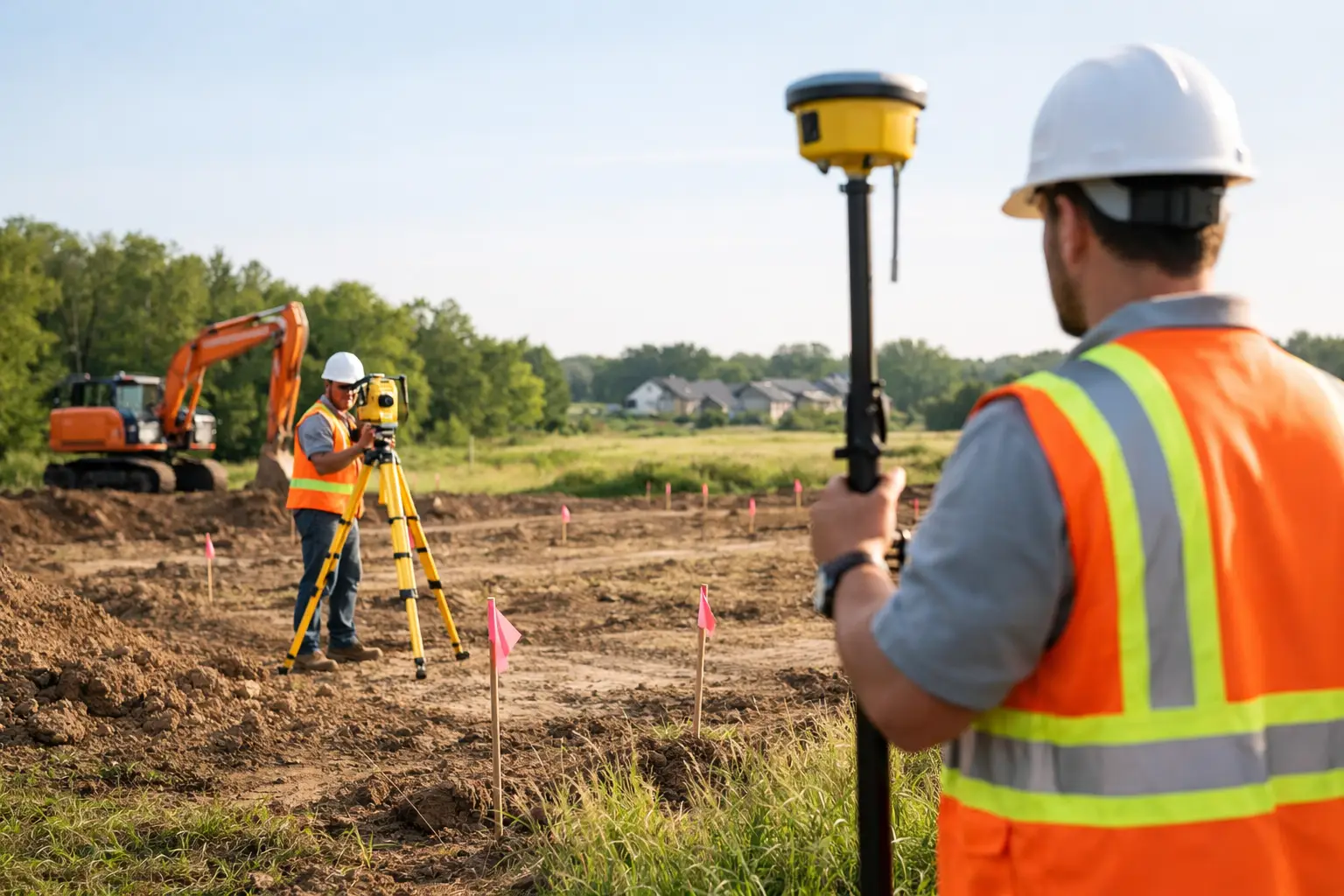
Prepare land for subdivision survey by clearing access
The first practical step is access. Your surveyor needs to move across the whole site, not just the easy parts near the street. If there are side passages, rear yards, overgrown fence lines or steep sections, those areas should be accessible before the survey date.
This does not mean stripping the block bare. It means removing obstacles that stop measurements being taken properly. Long grass, dense scrub, stacked materials, temporary fencing, rubbish piles and locked gates are common problems. If the surveyor cannot physically reach a feature or boundary line, it may not be able to be located with the accuracy needed.
On residential sites, it also helps to move vehicles, trailers, boats and building materials away from key areas. On development sites, make sure machinery, stored pallets and site sheds are not sitting over boundary corners, service pits or other important features.
If parts of the land are occupied by tenants, neighbours or contractors, organise access in advance. A missed appointment with one adjoining owner can be enough to delay the whole job.
Gather the documents before the field work starts
One of the fastest ways to improve survey efficiency is to provide the background documents early. Even when a registered surveyor carries out title and plan searches, client-supplied information can still be useful, especially if there have been previous approvals, private works or unresolved title issues.
Relevant documents may include a current title reference, deposited plans, old survey plans, subdivision approvals, easement documents, sewer diagrams, architectural drawings, engineering concepts and any council correspondence already received. If you have reports from previous consultants, those can also help identify known issues before field work begins.
The reason this matters is simple. A survey is stronger when the field evidence and documentary evidence can be reviewed together. If an old fence does not match the title dimensions, or an easement affects the proposed lot layout, it is better to know that early than after design work has already begun.
Know where the boundaries are – or do not assume
Property owners often have a rough idea of where their boundaries sit. Sometimes they are right. Sometimes the back fence has drifted over time, a retaining wall has been built across the line, or a corner peg disappeared years ago.
Before a subdivision is designed around existing occupation, boundary definition should be handled properly. That may involve a cadastral survey, boundary re-establishment or mark-out work depending on the site and project stage. Relying on what looks right can create expensive redesign later, particularly where setback compliance, lot area or access width is tight.
If your project depends on a narrow driveway handle, a secondary dwelling being retained, or a proposed new lot meeting minimum dimensions, a few hundred millimetres can make a real difference. This is where registered survey input is critical, not optional.
Services and underground constraints need attention too
Subdivision planning is not just about fences and lot lines. Existing services can influence what is practical and what council or servicing authorities will accept. Sewer, stormwater, water, power and telecommunications infrastructure may all affect the final design.
Before the survey, identify any known service locations, access covers, pump systems, on-site detention works, septic systems or private drainage lines. If there are service plans available, pass them on. If there are concealed features you already know about, mention them even if they do not appear on title documents.
This is especially relevant on older Central Coast properties, where years of additions and repairs may have created undocumented drainage paths, filled land, retaining works or service alignments that do not match the original plan.
Make the site safe and workable
Surveyors are used to working on active building sites, sloping land and difficult terrain, but there are limits. If the site is unsafe, wet, unstable or obstructed by uncontrolled hazards, field work may need to be postponed.
Basic preparation helps. Secure animals, unlock gates, notify occupants, identify unstable ground and ensure the surveyor can move around without unnecessary risk. If there are waterfront edges, thick vegetation, recent excavation, demolition works or damaged structures, make that clear before the visit.
For larger sites, it is also worth nominating one contact person who understands the property and can answer questions quickly. That avoids wasted time when access points, occupation history or service locations need to be clarified on the day.
Timing can change the outcome
The best time to survey a site is not always the first available date. If demolition is scheduled, it may be smarter to capture existing structures before they come down if those structures affect approvals or title matters. If bulk earthworks are about to begin, existing levels may need to be surveyed first. If the grass is waist-high after heavy rain, a short delay for slashing may save time overall.
This is one of those areas where it depends on the project. For some subdivisions, early detail and contour survey work should happen before any physical changes occur. For others, a staged approach makes more sense, with initial survey, design coordination, set-out and final plan work happening at different points.
A practical surveyor will usually advise on the best sequence. That is part of reducing rework and controlling cost.
Working with the rest of the consultant team
Subdivision surveying rarely happens in isolation. Architects, town planners, civil engineers, certifiers and project managers all rely on accurate survey information, but they may need different outputs at different times.
If you are managing the project, let your surveyor know who else is involved and what stage the design has reached. A concept subdivision layout, stormwater strategy or council pre-lodgement issue can change the survey scope. The more coordinated the consultant team is, the fewer surprises appear later.
This is where an end-to-end approach is valuable. A local firm such as Central Coast Surveyors can coordinate from initial detail and contour survey through subdivision plan preparation and registration, which helps keep the technical work consistent across the life of the project.
Common mistakes when people prepare land for subdivision survey
The most common mistake is treating the survey as a formality. It is not. The survey data often drives the design, highlights constraints and exposes title or occupation issues that affect the entire project.
The second mistake is underestimating site conditions. Owners may assume a survey can be done around dense vegetation, locked rear access, tenant storage or unmarked changes to the land. Sometimes it can. Often it leads to slower field work, incomplete pickup or the need for a return visit.
The third mistake is holding back information because it seems minor. Old drainage, neighbour agreements, previous fence disputes, informal access arrangements and known encroachments should be raised early. Even if they do not alter the survey method, they may affect advice on the subdivision pathway.
A better result starts before the surveyor arrives
If you want the subdivision process to run cleanly, preparation is part of the job. Clear the access, gather the plans, flag the known issues and speak up about anything unusual on the site. That gives your surveyor the best chance to capture accurate data quickly and gives the wider project team something reliable to work from.
A well-prepared site does not guarantee a simple subdivision, because every parcel has its own constraints. But it does put the project on firmer ground from day one, which is exactly where good decisions start.