
NSW Building Certificate Survey Guide for Owners
A building certificate application can stall quickly when the plans do not clearly show where an existing structure sits in relation to the legal boundaries. This NSW building certificate survey guide explains when an identification survey is likely to be needed, what it establishes, and how to prepare the right information before lodging with council.
For Central Coast property owners, this commonly arises when selling a home, resolving an older approval issue, dealing with an addition close to a boundary, or responding to a council request. The survey is not simply a drawing exercise. It provides measured evidence that helps the certifier, planner, solicitor and council assess the building in its actual position on the land.
What is a NSW building certificate?
A building certificate is issued by the local council under the Environmental Planning and Assessment Act 1979. It relates to an existing building and can provide protection from certain council orders for a period of seven years, subject to important exceptions. It is often sought where there is uncertainty about approvals, changes to a building over time, or a structure that may not align with approved plans.
A certificate does not make an unsafe building safe, remove every legal risk, or confirm that a property is free of defects. Council may still require further information, inspections or reports before making a decision. Conditions affecting flooding, bushfire, heritage, health and safety, or unauthorised work can change what is required.
The key point is that council needs reliable information about the building it is being asked to consider. Where location is relevant, an identification survey is often the document that establishes the facts on the ground.
When an identification survey is needed
Council requirements vary depending on the property, the building and the reason for the application. An identification survey may be requested where a building, garage, deck, retaining wall, pool, carport or extension is close to a boundary. It can also be useful if existing plans are incomplete, the title contains easements, or there is doubt about whether an improvement crosses a boundary.
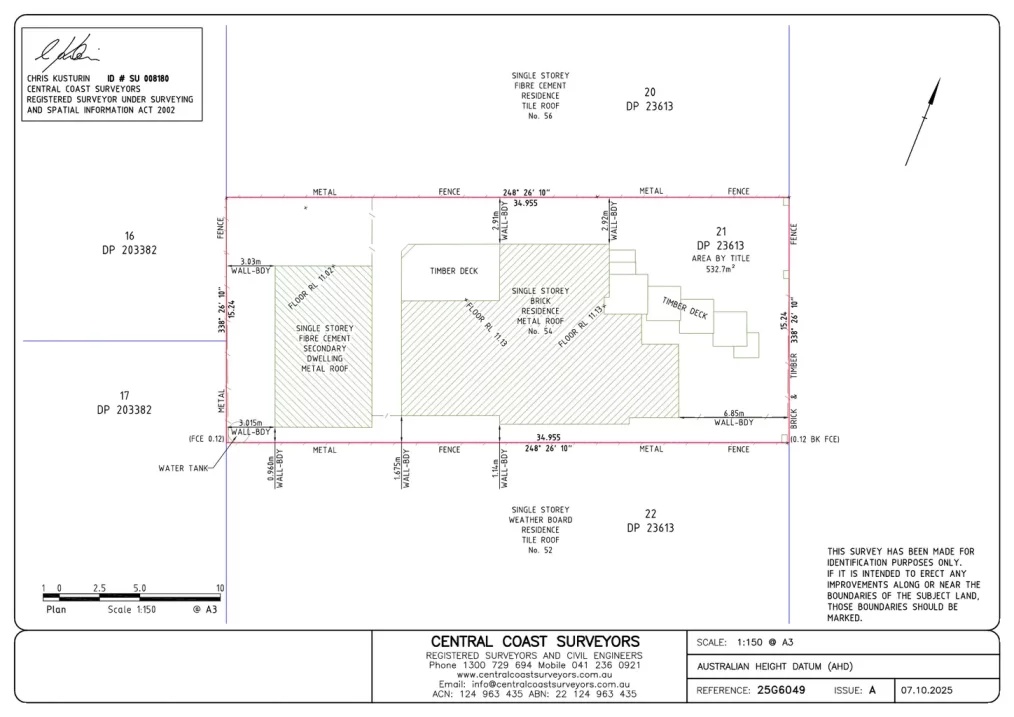
The survey plan identifies the parcel of land by reference to title information and survey evidence, then shows the existing improvements in relation to the boundaries. It may reveal that a structure is fully within the allotment, sits close to a boundary, or extends beyond it. Each outcome has different implications, and none should be assumed from aerial imagery, old marketing plans or fence lines.
On established Central Coast sites, fences can be particularly misleading. They may have been installed for convenience, follow an old occupation line, avoid rocks or trees, or simply be in the wrong place. A fence is not proof of the legal boundary.
Building certificates are not all the same
Some applications can proceed with architectural plans, photos and other supporting reports. Others need a current identification survey because the relationship between the building and the title boundaries is central to council’s assessment. The most efficient approach is to check the application requirements early rather than commissioning documents after council requests more information.
If the issue involves a potential encroachment, an easement, a waterfront licence area or a proposed boundary adjustment, the scope may extend beyond a standard identification survey. A registered surveyor can assess the title, the site conditions and the purpose of the plan before recommending the appropriate work.
What the surveyor does on site and in the office
A proper identification survey starts well before fieldwork. The surveyor reviews deposited plans, title information, relevant survey records and available council or consultant documentation. This research is necessary to determine how the boundaries can be accurately re-established.
On site, the survey team locates physical evidence such as survey marks, occupation features, buildings, walls and other improvements relevant to the brief. Modern equipment improves field efficiency, but the result still relies on professional judgement, cadastral knowledge and a careful assessment of the available evidence.
The registered surveyor then analyses the measurements against the title framework and prepares a plan showing the relationship between the improvements and the parcel boundaries. Depending on the brief, the plan may identify offsets from walls to boundaries, encroachments, registered easements, building outlines and relevant structures.
An identification survey is different from a topographical survey. A detail and contour survey records levels, surface features and site conditions for design. It may be useful for an architect or engineer, but it does not necessarily establish title boundaries. Likewise, a boundary mark-out physically indicates boundary positions on the ground, while an identification survey documents the location of improvements relative to those boundaries. The right service depends on what council, your solicitor or your project team needs to assess.
Information to provide before the survey begins
Early information helps avoid rework and allows the survey scope to match the certificate application. Provide the current title details or property address, any council correspondence, approved plans you hold, old survey plans, and a clear explanation of why the building certificate is being sought.
It also helps to identify the structures in question. For example, say whether council needs information about a rear deck, an enclosed patio, a detached studio or the whole dwelling. If a neighbour has raised a boundary concern, explain that at the outset. The surveyor needs to understand the decision the plan will support, not just the address.
Access matters too. Locked gates, dogs, dense vegetation, stored materials and restricted side access can affect field time and the ability to measure all relevant improvements. Where possible, arrange clear access and advise tenants or occupants before the booking.
Common issues that can affect timing and cost
Straightforward residential surveys can be completed efficiently when title evidence is clear, access is available and the relevant structures are visible. Older properties and constrained sites often need more investigation. This is not unnecessary process – it is what protects the accuracy of the final plan.
The following issues commonly change the scope:
- missing, damaged or disturbed survey marks
- buildings or decks very close to a boundary
- sloping, heavily vegetated or waterfront land
- multiple easements, restrictions or complicated title history
- structures that cannot be measured because of access constraints
- inconsistencies between older plans and the existing building.
An apparent encroachment should be handled carefully. It may be minor, it may affect only a non-structural element, or it may need legal, planning or neighbour discussions. A surveyor establishes position and prepares reliable documentation; legal rights, agreements and approval pathways should then be considered with the appropriate professionals.
How to avoid delays in a building certificate application
The practical goal is to give council clear, consistent material the first time. Start by reading the council’s current building certificate checklist and identify exactly what it requires for your site. If an identification survey is requested, avoid substituting a real estate plan, an old sketch or a general site plan unless council has confirmed it will accept it.
Coordinate the survey with the rest of the application. Your building designer, planner, certifier or solicitor may need the final survey plan to prepare supporting documents, explain a variation or address an encroachment. Sending the plan through early reduces the risk of conflicting dimensions appearing across the application.
Do not leave the survey until settlement, construction or a council response deadline is imminent. Although rapid turnaround may be possible, survey work can be affected by weather, access, the availability of records and the complexity of boundary evidence. Allowing reasonable lead time gives your surveyor the opportunity to investigate properly and gives the wider project team time to act on the findings.
Choosing the right survey support
For building certificate work, use a registered surveyor with experience in identification surveys and cadastral boundary determination. Registration matters because the work can influence council decisions, property transactions and discussions with adjoining owners. Ask what the plan will show, what documents are needed before fieldwork, whether the scope addresses council’s request, and what factors could affect the programme.
A local team also brings practical familiarity with the building patterns and site constraints found across the Central Coast, from older coastal cottages and steep blocks to established suburban properties with long-standing fences. Central Coast Surveyors works with owners and project consultants to clarify the survey requirement early, prepare accurate plans and keep the approval process moving with straightforward communication.
Before you lodge, make sure every document tells the same story: the address and title details are correct, the structures shown match the application, and any issue identified by the survey has been addressed with the right advice. That preparation gives council a clearer basis for assessment and gives you fewer surprises once the application is underway.